
Smylie Channel facts for kids


The Smylie Channel is a narrow stretch of sea in the Falkland Islands. It is about 1.4 kilometers (0.9 miles) wide and 16 kilometers (10 miles) long. This channel acts like a watery path, separating Weddell Island to the north from West Falkland and Dyke Island to the south. You can find it centered at 51°59′04″S 61°03′48″W.
What is Smylie Channel?
The Smylie Channel is an important waterway in the Falkland Islands. It helps connect different parts of the sea around the islands. Channels like this are often used by boats and ships to travel between islands or reach different bays.
Geography of the Channel
This channel is located in the western part of the Falkland Islands. To its north is Weddell Island, which is one of the larger islands in the group. To the south, it borders the main island of West Falkland and the smaller Dyke Island. The channel's length means it provides a significant passage for water flow and marine life in the area.
Images for kids
-
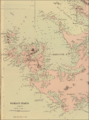
An old map of Weddell Island, showing French Harbour nearby.
-
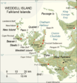
A map of Weddell Island, which borders the Smylie Channel.


