
Pitt Heights facts for kids


Pitt Heights is a notable high area located in the northwestern part of Weddell Island, one of the many islands that make up the Falkland Islands. This interesting geographical feature stretches about 7.5 kilometers (4.7 miles) from southwest to northeast and about 6.8 kilometers (4.2 miles) from southeast to northwest. It rises to a height of about 240 meters (787 feet) above sea level, making it one of the higher points on Weddell Island. Pitt Heights is centered around the coordinates 51°49′05″S, 61°00′30″W.
Contents
What are Pitt Heights?
Pitt Heights isn't a single tall mountain, but rather a raised area or a range of hills. It forms an important part of the landscape in the interior of Weddell Island. Imagine a large, gently sloping area that stands out from the land around it. This is what Pitt Heights is like. It's a significant landmark for anyone exploring the island.
Exploring Weddell Island
Weddell Island is the third-largest island in the Falkland Islands. It's known for its beautiful natural scenery and diverse wildlife. The island is mostly covered in tussac grass, which is a very tall, thick grass that provides shelter for many animals. While Pitt Heights itself might not be a specific wildlife hotspot, it's part of an island that is home to various birds and animals.
Wildlife of the Falkland Islands
The Falkland Islands, where Pitt Heights is located, are famous for their amazing wildlife. You can find different kinds of penguins, such as rockhopper penguins and gentoo penguins, waddling along the shores. There are also many types of seabirds, including albatrosses and cormorants. Sea lions and seals often rest on the beaches. The landscape, including areas like Pitt Heights, provides different habitats for these creatures.
Images for kids
-
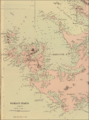
Old map of Weddell Island featuring Chatham Harbour
-
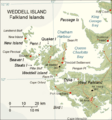
Map of Weddell Island


