Hotham Inlet facts for kids
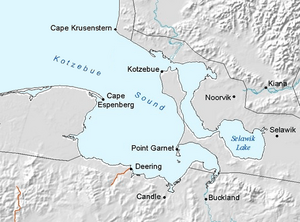
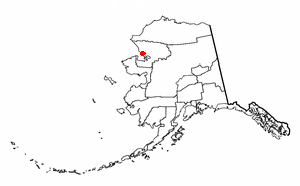
Hotham Inlet, also called Kobuk Lake, is a large arm of Kotzebue Sound in northwestern Alaska. It stretches about 50 miles (80 km) long and is 5 to 20 miles (8 to 32 km) wide. This inlet is where the Kobuk River and Selawik River flow out into the sea. The Baldwin Peninsula forms its southwest border.
The inlet was named in 1826 by Captain Frederick William Beechey of the Royal Navy. He named it after Sir Henry Hotham, who was an important leader in the British Admiralty.
Contents
Exploring Hotham Inlet's Geography
The eastern coast of Kotzebue Sound has many deep bays and inlets. Hotham Inlet is the biggest of these. It is a long, unevenly shaped body of water. A narrow strip of land separates it from the main sound. The three largest rivers that flow into Kotzebue Sound—the Noatak, the Kobuk, and the Selawik—all empty into Hotham Inlet.
The Selawik River's Path
The Selawik River is the southernmost of the three rivers. It flows into Selawik Lake. This lake then connects to the top of Hotham Inlet through a narrow waterway. Selawik Lake likely formed because the Kobuk River's delta grew so much that it cut off part of the inlet. Several smaller bodies of water to the east are also connected to this larger basin by channels where tides flow.
The Kobuk River Delta
The eastern side of Hotham Inlet is made up of the wide delta of the Kobuk River. A delta is a landform created when a river deposits its sediment as it enters a larger body of water. The Kobuk River's source is about 200 miles (320 km) east of Hotham Inlet, in a high mountain area.
The lower part of the Kobuk River valley is a wide, flat area. The upper part has a series of basins and narrow canyons. Near the 161st meridian, the mountains on the north side of the Kobuk valley curve around the eastern arm of Hotham Inlet. The mountains on the south side end suddenly at the delta.
The Kobuk River delta is about 30 miles (48 km) square. It is bordered by Selawik Lake to the south and Hotham Inlet to the west and north. This delta has many winding waterways, lakes, and lagoons. It is constantly growing outwards into the shallow waters of Hotham Inlet.
The Noatak River's Journey
The Noatak River is the third and possibly the largest of the three rivers flowing into Kotzebue Sound from the east. Its source is near the sources of the Colville and Kobuk rivers. The Noatak generally flows west until it is about 30 miles (48 km) from the coast. Then, it sharply turns and flows south to reach the sea at the northern end of Hotham Inlet.
See also
 In Spanish: Hotham Inlet para niños
 | Janet Taylor Pickett |
 | Synthia Saint James |
 | Howardena Pindell |
 | Faith Ringgold |


