
Hubbard Glacier facts for kids
Quick facts for kids Hubbard Glacier |
|
|---|---|

False color image of the Hubbard Glacier
|
|

Hubbard Glacier
Location in Alaska
|
|
| Type | Tidewater/Mountain glacier AKA Valley Glacier |
| Coordinates | 60°18′50″N 139°22′15″W / 60.31389°N 139.37083°W |
| Length | 122 kilometres (76 mi) |
| Terminus | Sealevel |
| Status | Advancing |
Hubbard Glacier is a giant river of ice. It is found in Wrangell–St. Elias National Park and Preserve in Alaska, USA. Part of it also stretches into Kluane National Park and Reserve in Yukon, Canada. The local Lingít people call it Sít' Tlein, which means "Big Glacier." This amazing natural wonder was named after Gardiner Greene Hubbard, a notable American.
Contents
Exploring the Hubbard Glacier


The Hubbard Glacier is one of the longest glaciers in North America. Its main source of ice starts about 122 kilometres (76 mi) away from its "snout." The snout is the very end of the glacier. This starting point is high up, around 3,400 metres (11,200 ft) in elevation. Another smaller stream of ice, called a tributary glacier, begins even higher. It starts near Mount Logan at about 5,600 metres (18,400 ft).
As the Hubbard Glacier flows towards the sea, it meets another glacier called the Valerie Glacier. The Valerie Glacier adds its ice to Hubbard. Sometimes, these glaciers have "surges." A surge is when the ice moves forward much faster than usual. These surges have caused the Hubbard Glacier to grow and push forward.
The Glacier's Big Blockades
For about 100 years, the Hubbard Glacier has been slowly moving forward. In May 1986, it surged ahead quickly. This surge blocked the entrance to Russell Fjord, a long, narrow inlet of the sea. This created a new lake called Russell Lake. All that summer, the lake filled with fresh water from melting ice and rain. Its water level rose by 25 metres (82 ft). This change made the water less salty, which was a danger to the sea creatures living there.
Then, on October 8, 1986, the natural ice dam broke. Over the next 24 hours, a huge amount of water, about 5.3 cubic kilometres (1.3 cu mi), rushed out. The fjord reconnected to the ocean. This event was the largest glacial lake outburst flood (GLOF) ever recorded. A GLOF happens when a glacier creates a dam, and then the dam breaks, releasing a lot of water very quickly.
In the spring of 2002, the glacier again moved close to blocking the fjord. It pushed a pile of rocks and dirt, called a terminal moraine, ahead of it. This moraine closed the opening again in July. However, on August 14, heavy rains caused the water behind this new dam to rise. The moraine was then washed away. The fjord has faced the risk of becoming dammed again. If this were to happen permanently, the fjord might overflow. It could then drain through the Situk River, which would affect trout and a local airport.
Icebergs and Ancient Ice
It takes about 400 years for ice to travel from the top of the glacier to its end. This means the ice you see at the foot of the glacier is about 400 years old! The Hubbard Glacier often "calves" off huge pieces of ice. Calving is when large chunks of ice break away from the glacier's edge. These icebergs can be as tall as a ten-story building.
Most of the glacier's ice is hidden below the water where it meets the bay. When new icebergs break off, they can shoot up dramatically from the water. Because of this, ships must keep a safe distance from the glacier's edge in Disenchantment Bay.

A Close Encounter: Ship and Ice
On June 25, 2022, a cruise ship called the Norwegian Sun had an incident. It was sailing near the Hubbard Glacier for sightseeing in foggy weather. The ship hit a "growler," which is a piece of ice smaller than an iceberg. The ship was damaged but remained safe. It had to end its trip early and sail back for checks and repairs.
A Ferry Named Hubbard
The Alaska Marine Highway System has a ferry named MV Hubbard. This ferry was named after the Hubbard Glacier. A local student, Taylor Thompson, chose this name. Taylor's essay won a contest to name the new ferry.
Images for kids
-
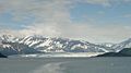
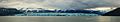
The glacier from a distance
-
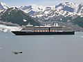
Holland America Line's MS Oosterdam passing Turner Glacier while leaving Disenchantment Bay
-
Hubbard Glacier and icebergs formed by calving
-
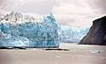
Closeup of Hubbard Glacier
-
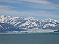
The glacier relatively close
-
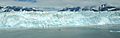
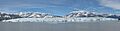
Panoramic view
-
A wide view of the glacier.


See also
 In Spanish: Glaciar Hubbard para niños
- Glacial lake outburst flood
- Ice calving
