Humboldt, Wisconsin facts for kids
Quick facts for kids
Humboldt, Wisconsin
|
|
|---|---|

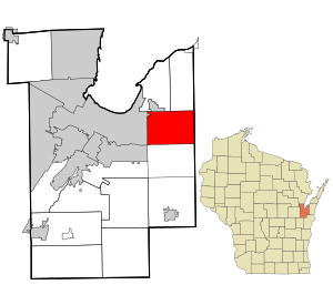
Location in Brown County and the state of Wisconsin.
|
|
| Country | |
| State | |
| County | Brown |
| Area | |
| • Total | 24.0 sq mi (62.2 km2) |
| • Land | 24.0 sq mi (62.2 km2) |
| • Water | 0 sq mi (0.0 km2) |
| Elevation | 801 ft (244 m) |
| Population
(2010)
|
|
| • Total | 1,311 |
| • Density | 55/sq mi (21.1/km2) |
| Time zone | UTC-6 (Central (CST)) |
| • Summer (DST) | UTC-5 (CDT) |
| Area code(s) | 920 |
| FIPS code | 55-36425 |
| GNIS feature ID | 1583422 |
Humboldt is a town in Brown County in the U.S. state of Wisconsin. It is a small community. In 2010, about 1,311 people lived here. Henry Fontaine chose the name for the town.
Communities in Humboldt
Humboldt is home to a few smaller communities. These are places where people live, but they are not officially separate cities or villages.
- Humboldt is a community located where County Road N and T meet.
- New Franken is another community mostly within Humboldt. It is found along County Road T, south of WIS 54. A small part of New Franken is in the town of Scott.
- Sugar Bush is a community located where County Road N and Sugar Bush Road cross paths.
Geography of Humboldt
Humboldt is in the eastern part of Brown County. To its east is Kewaunee County. The city of Green Bay borders Humboldt to the west and north.
The United States Census Bureau says that Humboldt covers about 62.2 square kilometers (24.0 square miles). All of this area is land.
Population Facts
In 2000, there were 1,338 people living in Humboldt. There were 453 households, which are groups of people living together. Most people living in Humboldt were White.
The population was spread out by age. About 28.3% of the people were under 18 years old. Around 9.0% were between 18 and 24. A large group, 29.4%, were between 25 and 44 years old. About 9.6% of the population was 65 years or older. The average age in Humboldt was 36 years.
See also
 In Spanish: Humboldt (Wisconsin) para niños

