Ilford, New South Wales facts for kids
Quick facts for kids IlfordNew South Wales |
|
|---|---|
 |
|
| Population | 187 (2016 census) |
| Postcode(s) | 2850 |
| LGA(s) | Mid-Western Regional Council |
| State electorate(s) | Bathurst |
| Federal Division(s) | Calare |
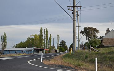
Ilford is a small village in New South Wales, Australia. It is located next to the Crudine River, within the Mid-Western Regional Council area. You can find Ilford on the Castlereagh Highway, which locals often call the 'Sydney Road'. It's about 220 kilometres north-west of Sydney.
In 2016, Ilford and the nearby rural areas had a population of 187 people. The village was named after a town in England called Ilford, which is now part of Greater London. Some of the first people to settle here came from that English town.
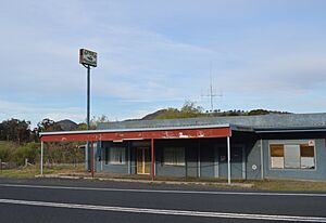
When you pass through Ilford, it looks like a small group of buildings. These buildings are mostly around a T-junction where the Bathurst-Ilford Road meets the Castlereagh Highway. The main gathering place for the community is the Ilford Public School. There is also a rest stop with toilets for travellers on the northern side of the village.
Contents
History of Ilford: How the Village Grew
Ilford was first known by a different name: Kean's Swamp. In June 1853, a piece of land was set aside at Kean's Swamp. This land was planned to become a town.
Early Days and Mail Services
In December 1860, people from the Hartley area had a public meeting at the "School-house" in Kean's Swamp. They met to choose a person to represent them in the New South Wales Parliament.
By January 1863, mail was being carried by horseback to and from Kean’s Swamp and Sofala twice a week. Michael Moore, who lived in Kean's Swamp, was the person who won the contract to deliver the mail.
From Kean's Swamp to Ilford
In March 1868, an important change happened. The post office that was known as Kean's Swamp officially changed its name to ‘Ilford’. This was a big step for the growing community.
What Ilford Looked Like in the Past
In June 1874, a visitor described Ilford as a very pretty place. It was located at the bottom of a mountain. At that time, the village had four stores, and one of them, Mrs. Phelps’ store, also served as the Post Office. There was also an inn called The Plough. The only church was a stone-built Wesleyan church. The public school building was described as a "miserable slab building," meaning it was quite basic.
By November 1875, Ilford had grown a bit more. It had two churches, one Episcopalian and one Wesleyan. The village had about 100 people living there. The buildings were described as "neat and substantial." Businesses included two stores, a public-house (like a pub), a carpenter’s shop, a bakery, a butchery, and the post office. A new school building was started in September 1877 and finished in late 1877 or early 1878.
In November 1880, two people were given licenses to run pubs in Ilford. Mrs. Elizabeth Donovan ran the Carriers' Arms, and Robert Moore ran The Plough Inn. By 1881, Ilford village had 162 people.
The Railway's Impact on Ilford
In June 1884, a new railway line was built. It connected Capertee to Rylstone. This railway line went past Ilford village to the east. However, there was a station named Ilford on this new line, even though it was about eight miles north-east of the actual village. This distance was a big problem for Ilford.
The railway station was called Ilford until 1900, when its name was changed to Mornington. Later, in 1903, it was briefly called Carwell, and then in 1905, it was renamed Clandulla. This railway station, which is now closed, is where the modern village of Clandulla is located today. The railway by-passing the village caused Ilford to slowly decline from the mid-1880s.
By 1891, Ilford village had 92 people. In 1901, the population had dropped to 71.
In July 1922, a visitor described Ilford as a "place of the past." They said it was one of the towns that grew because of horse-drawn wagons, but the railway had caused it to decline. Many houses were falling apart, and the police station was empty. However, there was still "an up-to-date store" and a "rabbit works," which processed rabbits to send to Sydney. The local school was a good building, but it had very few children attending.
In July 1926, a new sawmill started working in Ilford. It was run by the Ilford Co-operative Sawmilling Society Ltd. However, this company went bankrupt in 1931 and closed down in May 1932.
Astronomy and Star Gazing
Ilford is a special place for people who love looking at the stars! The Astronomical Society of New South Wales owns a property called 'Wiruna' just outside Ilford. This place is known as one of Australia's best spots for observing the night sky because it has very little light pollution. Members and guests of the society use it often.
Every year since 1993, the Astronomical Society has hosted a big event there called the "South Pacific Star Party." This event brings together between 200 and 400 amateur star-gazers from Australia and other countries. It's a huge gathering that almost doubles the population of the area for the weekend! The local Scouts also help out by providing hot food, which helps them raise money for their activities.
How to Get to Ilford
- If you are coming from Capertee, you can travel along the Castlereagh Highway (Sydney Road).
- From Mudgee, you also travel along the Castlereagh Highway (Sydney Road).
- If you are coming from Sofala, take the Bathurst-Ilford Road (MR 54).
- From Kandos, you can travel along the Bylong Valley Way to reach the Castlereagh Highway (Sydney Road).
 | Sharif Bey |
 | Hale Woodruff |
 | Richmond Barthé |
 | Purvis Young |


