
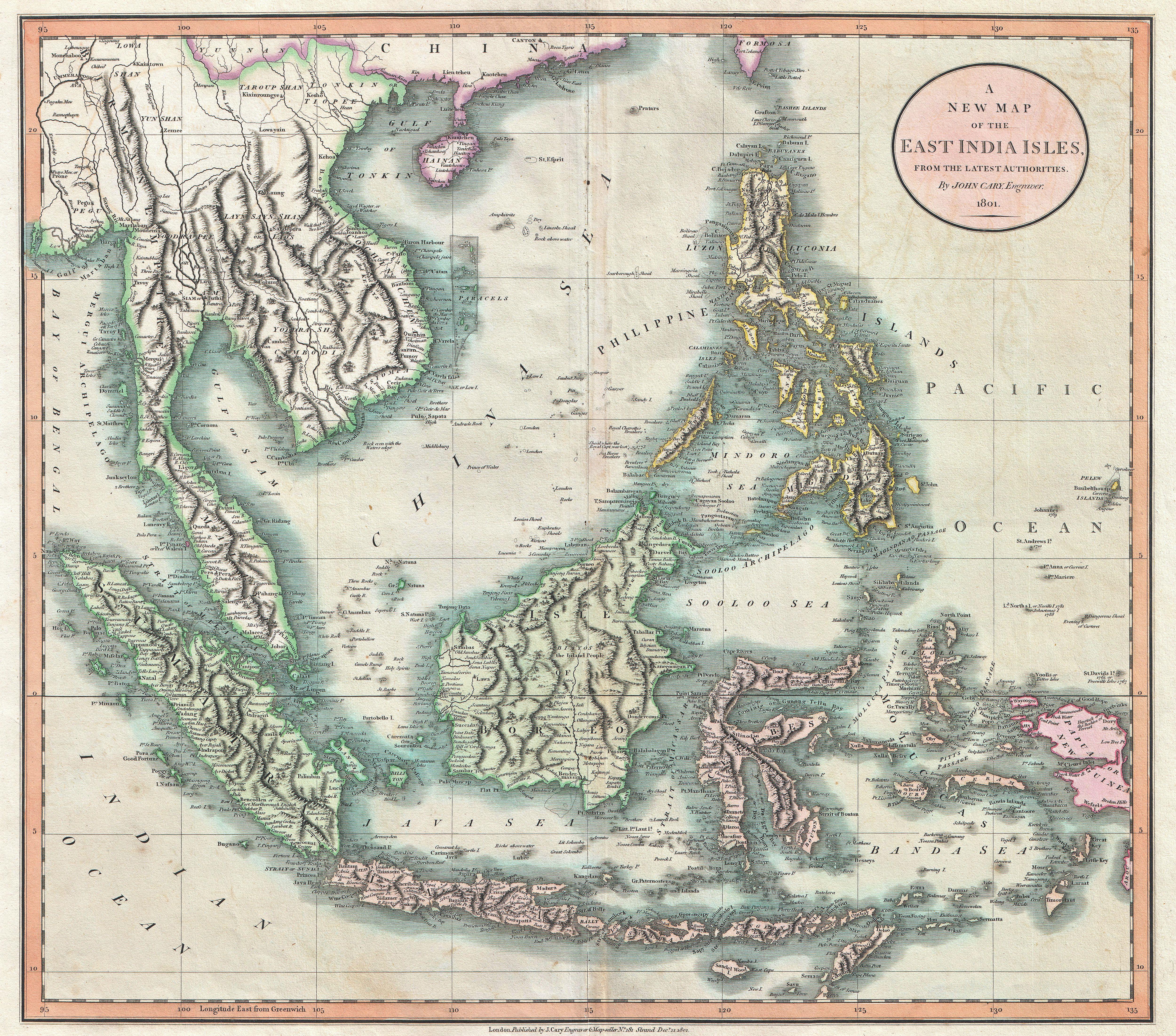
Image: 1801 Cary Map of the East Indies and Southeast Asia ( Singapore, Borneo, Sumatra, Java, Philippines) - Geographicus - EastIndies-cary-1801
Description: An exceptionally beautiful example of John Cary’s important 1801 Map of the East Indies. Covers all of Southeast Asia and the Malay Peninsula, including Singapore, as well as the Philippines, Borneo, Sumatra, java, the Celebes, and parts of Papua New Guinea. One of the few maps of this region to label the volcanic island of Krakatoa between Java and Sumatra, which famously erupted, obliterating the entire island in 1883. Notes the Straits of Singapore at the southern tip of the Malay Peninsula. Offers wonderful detail regarding the mountain ranges of the region. Also shows some off shore details, especially the shoals near Borneo and the Philippines. In Southeast Asia this map notes the kingdoms of Siam (Thailand), Tonkin (North Vietnam), Cochin (South Vietnam), Cambodia, and Pegu (Burma). Includes part of the Island of Formosa. All in all, one of the most interesting and attractive atlas maps of the East Indies to appear in first years of the 19th century. Prepared in 1801 by John Cary for issue in his magnificent 1808 New Universal Atlas .
Title: A New Map of the East India Isles, from the Latest Authorities.
Credit: Cary, John, Cary's New Universal Atlas, containing distinct maps of all the principal states and kingdoms throughout the World. From the latest and best authorities extant. London: Printed for J. Cary, Engraver and Map-seller, No. 181, near Norfolk Street, Strand, 1808. This file was provided to Wikimedia Commons by Geographicus Rare Antique Maps, a specialist dealer in rare maps and other cartography of the 15th, 16th, 17th, 18th and 19th centuries, as part of a cooperation project. Deutsch | English | français | македонски | Nederlands | polski | +/−
Author: This file is lacking author information.
Permission: This is a faithful photographic reproduction of a two-dimensional, public domain work of art. The work of art itself is in the public domain for the following reason: This work is in the public domain in its country of origin and other countries and areas where the copyright term is the author's life plus 100 years or less. You must also include a United States public domain tag to indicate why this work is in the public domain in the United States. This file has been identified as being free of known restrictions under copyright law, including all related and neighboring rights. The official position taken by the Wikimedia Foundation is that "faithful reproductions of two-dimensional public domain works of art are public domain". This photographic reproduction is therefore also considered to be in the public domain in the United States. In other jurisdictions, re-use of this content may be restricted; see Reuse of PD-Art photographs for details.
Usage Terms: Public domain
License: Public domain
Attribution Required?: No
Image usage
The following 3 pages link to this image:

_-_Geographicus_-_EastIndies-cary-1801.jpg)