
Spratly Islands facts for kids
The Spratly Islands are about 100 small, empty islands in the South China Sea. Many fish live around them, and they might have oil and natural gas. Because of this, countries like China, Malaysia, Philippines, Taiwan, and Vietnam are very interested in them. These countries share some control over the islands, but each one wants to control all or most of them.
What the Islands are Like
In 1939, the Spratly Islands were mostly small coral islands where seabirds lived. The islands are made up of many small landforms. These include 14 islands or islets, 6 banks, 113 underwater reefs, 35 underwater banks, and 21 underwater shoals.
The northeast part of the Spratlys is called Dangerous Ground. It has many low islands and hidden reefs. These reefs often rise sharply from very deep ocean water, making the area risky for ships.
All the islands are similar. They are cays, which are sandy islands formed on old, sunken coral reefs.
Resources and Activities
The Spratly Islands have almost no good land for farming. No people live there permanently, and only a few islands have a steady supply of drinking water.
The islands have natural resources like fish, guano (bird droppings used as fertilizer), oil, and natural gas. People do things like commercial fishing, shipping, mining guano, and finding oil and gas. More recently, some tourism has started. The Spratlys are also close to important shipping routes.
In 1987, China built a small military structure on Fiery Cross Reef. They said it was to build an ocean observation station. After a fight with the Vietnamese Navy, China built more military structures on other reefs. This caused more tension between these countries and China over who owns the reefs.
Main Islands
Here are some of the larger natural islands in the Spratlys, listed by their size:
| # | Island name | Area (hectares) |
Currently controlled by |
|---|---|---|---|
| 1 | Itu Aba Island | 46.00 | Taiwan |
| 2 | Thitu Island | 37.20 | Philippines |
| 3 | West York Island | 18.60 | Philippines |
| 4 | Spratly Island | 13.00 | Vietnam |
| 5 | Northeast Cay | 12.70 | Philippines |
| 6 | Southwest Cay | 12.00 | Vietnam |
| 7 | Sin Cowe Island | 8.00 | Vietnam |
| 8 | Nanshan Island | 7.93 | Philippines |
| 9 | Sand Cay | 7.00 | Vietnam |
| 10 | Loaita Island | 6.45 | Philippines |
| 11 | Swallow Reef | 6.20 | Malaysia |
| 12 | Namyit Island | 5.30 | Vietnam |
| 13 | Amboyna Cay | 1.60 | Vietnam |
| 14 | Grierson Reef | 1.60 | Vietnam |
| 15 | West London Reef | 1.10 | Vietnam |
| 16 | Central London Reef | 0.88 | Vietnam |
| 17 | Flat Island | 0.57 | Philippines |
| 18 | Lankiam Cay | 0.44 | Philippines |
The total natural land area of all the islands is about 177 hectares. With land that has been added by people, the total area is around 200 hectares.
Images for kids
-
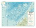
The Spratly Islands
-
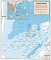
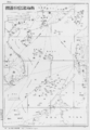
A map of the Spratly Islands
-
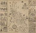
The Velarde map shows Philippine control over Scarborough Shoal and islands near Palawan, which are part of the Spratly Islands. This map was important in a case that challenged China's claims.
-
The Spratlys, called "Los Bajos de Paragua" on the 1734 Murillo Velarde map. Some parts of the Spratlys were then seen as part of Palawan.
-
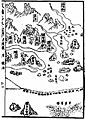
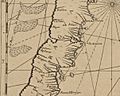
The Mao Kun map might show the Spratly Islands at the bottom right.
-
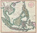
An 1801 map of Southeast Asia with islands similar to those on the Mao Kun map.
-
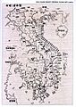
An 1838 map marking Trường Sa and Hoàng Sa. Some Vietnamese scholars believe these are the Spratly and Paracel Islands.
-
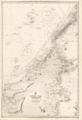
A large British map of the sea in northern Borneo, first made in 1881.
-
China's (now ROC and PRC) nine-dash line claim over the South China Sea, 1947.
-
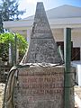
A monument from the Republic of Vietnam on Southwest Cay, showing it was part of Vietnamese land.
-
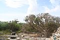
An old Heliotropium foertherianum tree on Spratly Island.
-
Young Vietnamese people living on Spratly Island.
-
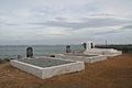
A military cemetery for Vietnamese soldiers on Central London Reef.
-
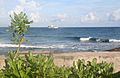
A view from Amboyna Cay.
-
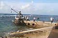
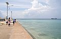
The Pearson Reef dock, managed by Vietnam.
.jpg)


_-_Geographicus_-_EastIndies-cary-1801.jpg)


See also
 In Spanish: Islas Spratly para niños
