
Nine-dash line facts for kids
Quick facts for kids Nine-dash line |
|||||||
|---|---|---|---|---|---|---|---|

The nine-dash line (in green)
|
|||||||
| Chinese name | |||||||
| Traditional Chinese | 九段線 | ||||||
| Simplified Chinese | 九段线 | ||||||
| Literal meaning | nine-segment line | ||||||
|
|||||||
| Eleven-dash line | |||||||
| Traditional Chinese | 十一段線 | ||||||
| Simplified Chinese | 十一段线 | ||||||
| Literal meaning | eleven-segment line | ||||||
|
|||||||
| Vietnamese name | |||||||
| Vietnamese alphabet | Đường chín đoạn | ||||||
| Literal meaning | nine-segment road | ||||||
The nine-dash line is a special line drawn on maps by the People's Republic of China (PRC). It shows the areas in the South China Sea that China claims as its own. Sometimes, it's also called the eleven-dash line by the Republic of China (ROC).
This claimed area includes important islands like the Paracel Islands and the Spratly Islands. It also covers other places such as Pratas Island and the Scarborough Shoal. Some countries, including China, Taiwan, and Vietnam, have even built new land in these areas. This is called land reclamation, and some of these new islands are known as the "Great Wall of Sand".
In 2016, an international court looked at China's claims. The court said that China's claim to "historic rights" over the waters inside the nine-dash line had no legal basis. This means China couldn't claim special rights to the resources there, like fish or oil. Both China and Taiwan rejected this decision.
Contents
What is the Nine-Dash Line?
The nine-dash line is a series of dashes on maps. It outlines a large area in the South China Sea. This area is rich in natural resources and is a very busy shipping route. Many countries have claims in this sea, leading to disagreements.
The People's Republic of China (mainland China) uses the nine-dash line. The Republic of China (Taiwan) uses a similar line with eleven dashes. This shows that both governments claim these areas.
History of the Line
How the Line Started
The idea of this line first appeared after World War II. In 1946, the Republic of China (ROC) government published a map. This map showed a U-shaped line with eleven dashes. It was meant to show the islands that China claimed.
Later, in 1949, the Communist Party took control of mainland China. They formed the People's Republic of China (PRC). The PRC then changed the map. They removed two dashes in the Gulf of Tonkin. This reduced the line to nine dashes. This change was seen as a friendly gesture to North Vietnam.
Even after this change, the ROC government in Taiwan still uses the original eleven-dash line. This shows their continued claim to the area.
The Line on Modern Maps
In 2009, China sent maps with the nine-dash line to the United Nations. They stated that China has "undisputable sovereignty" over the islands and waters. Other countries like Malaysia, Vietnam, Indonesia, and the Philippines protested this claim.
Since 1984, some Chinese maps have also included a tenth dash. This dash is located to the east of Taiwan. It's not part of the South China Sea.
The exact meaning of the nine-dash line is not fully clear. China has not officially explained its legal basis. Some experts think it claims only the islands. Others believe it claims the entire sea area within the line. This lack of clarity causes many problems.
Ongoing Disputes
Countries Disagree with China
Many countries disagree with China's claim. The Philippines and Vietnam say the nine-dash line goes against international law. They refer to the United Nations Convention on the Law of the Sea (UNCLOS). This law sets rules for how countries can claim parts of the sea.
Vietnam even calls the line the "cow's tongue line." This shows how strongly they oppose it. The United States also believes in freedom of navigation in these waters. They want all ships to be able to pass through freely.
Overlapping Claims
Parts of China's nine-dash line overlap with other countries' waters. For example, it crosses into Indonesia's special economic zone near the Natuna islands. Indonesia believes China's claim there has no legal basis.
One problem with the nine-dash line is that it's not a clear border. It's not stable because it changed from eleven to nine dashes. It also doesn't have exact geographic coordinates. This makes it hard to know exactly what China is claiming.
International Court Ruling
The Philippines Takes Action
In 2013, the Philippines took China to an international court. This court was set up under the United Nations Convention on the Law of the Sea (UNCLOS). The Philippines wanted the court to decide on China's claims.
On July 12, 2016, the court made its decision. It ruled mostly in favor of the Philippines. The court said it would not decide who owns the land. But it did say that China had no "historic rights" to the resources within the nine-dash line. This means China could not claim special rights to fish or other resources in that area.
China and Taiwan Reject the Ruling
China rejected the court's decision. China's leader, Xi Jinping, said the ruling would not affect China's rights in the South China Sea. China had chosen not to take part in the court case.
Taiwan, which controls Taiping Island (the largest Spratly island), also rejected the ruling. They sent a coast guard ship to the island. This showed their continued claim to the area.
Some experts point out that powerful countries often reject international court rulings. This happens when they feel their national interests are at stake.
See also
 In Spanish: Línea de los nueve puntos para niños
- Baselines of the Chinese territorial sea
- First island chain
- Foreign policy of China
- List of irredentist claims or disputes
- Territorial disputes in the South China Sea
Images for kids
-
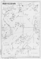
Location Map of South Sea Islands (南海諸島位置圖) circa 1947
-
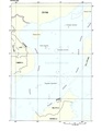
The nine-dash line map on the second page of PRC's 2009 submission to the UN
-
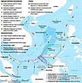
South China Sea claims and agreements.
-
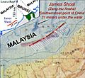
Dash 4 location in Chinese 2009 (solid red) and 1984 maps. James Shoal (Zeng-mu Ansha) is the "Southernmost point of China".


