Thitu Island facts for kids
|
Native name:
Pulo ng Pag-asa
|
|
|---|---|

Thitu Island
|
|
| Geography | |
| Location | West Philippine Sea |
| Coordinates | 11°03′08″N 114°17′00″E / 11.05222°N 114.28333°E |
| Archipelago | Spratly Islands |
| Administration | |
| Region | Southwestern Tagalog Region |
| Province | Palawan |
| Municipality | Kalayaan |
| Demographics | |
| Population | 193 |
Thitu Island, also known as Pag-asa Island, is a special place in the Spratly Islands. Its name, "Pag-asa," means "Island of Hope" in Filipino. It is the second largest natural island in the Spratly group. It is also the biggest island managed by the Philippines.
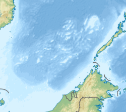
Pag-asa Island is about 500 kilometers (310 miles) west of Puerto Princesa. This city is in Palawan, Philippines. The island has other islands and reefs nearby. To the north is North Danger Reef. To the west is Subi Reef. To the south are the Loaita and Tizard Banks.
Pag-asa Island is the main town, or poblacion, of the Kalayaan municipality. This municipality is part of Palawan province in the Philippines. It also manages about a dozen other small islands and reefs in the Spratly Islands. However, China, Taiwan, and Vietnam also say they own the island.
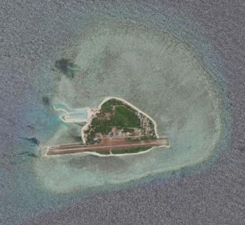
In 2019 and 2020, the island's naval port and airstrip were improved. This happened even though many Chinese ships were in the area. Pag-asa Island has a naval dock and a ramp for boats. It has an airstrip used by both military and civilian planes. There is also a lighthouse and a small clinic with five beds. A communication tower helps people stay connected. The island even has a small elementary and high school.
Most places in the Spratly Islands have only military people or visitors. But Pag-asa Island is special because it has people living there all the time.
Contents
What's in a Name?
The Filipino name for the island is Pag-asa, which means "Hope." It has many other names in different languages. In English, it's called Thitu Island. In Mandarin Chinese, it's Zhōngyè Dǎo. In Vietnamese, it's Đảo Thị Tứ. In Pangasinense, it's Ilalo, which also means "Hope."
Long ago, Chinese fishermen from the Hokkien group called it Thih-tu. This name means "Iron Shoal." Sometimes, people mistakenly call it "Tiezhi Island." This comes from a Mandarin Chinese way of saying "Iron Shoal Island." But "Tiezhi Reef" is actually another place. It is about 7.5 kilometers (4.7 miles) northeast of Pag-asa Island.
The modern Mandarin Chinese name, Zhōngyè Dǎo, comes from a battleship. This ship was named Chung-yeh. The Chinese government sent it in 1946 to take back control of the island. This was during the time of the Republic of China.
Island's Past
Early Times and Colonial Rule
Pag-asa Island has a long history. Records show that fishermen from Champa (now part of Vietnam) and China lived there at different times. During World War II, soldiers from French Indochina and Japan also stayed on the island.
In June 1763, a British ship called the Earl Temple sank near Pag-asa Island. It was on its way to Manila. Three sailors survived for months on the island. They built a raft and used bird feathers to make a sail. These sailors managed to reach Vietnam, then China, and finally returned to England. In 1997, Philippine officials found the shipwreck. They recovered items that are now shown at the National Museum of the Philippines.
From 1930 to 1933, the French government in French Indochina sent navy troops to the Spratly Islands. This included Pag-asa Island. On December 21, 1933, a French governor decided to make the Spratlys part of Bà Rịa Province. This province is now in Vietnam.
After World War II
Taking Control and Setting Up Government
After Japan lost World War II in 1945, officials from the Republic of China worked to get back the South China Sea Islands. They put up new national markers on the main islands. They also made detailed maps and gave the islands new names.
In May 1956, a Filipino man named Tomás Cloma landed on some of the islands. He said he had found them and claimed them. The Republic of China immediately said the islands belonged to them. They sent a letter to the Philippine Vice President. The Philippine government said Cloma's actions were his own and not related to the government.
In October 1956, two Chinese ships met Cloma's boat near North Danger Reef. They invited Cloma and his crew for a talk. During the discussion, Chinese crew members searched Cloma's boat. They took his weapons, maps, and papers. Cloma protested but was held. The next day, he was asked to sign a paper saying he would leave the islands. Cloma and his officers refused. Cloma was forced to give up his weapons. After the Chinese ships left, Cloma found that houses on some islands had been removed or burned down.
After these events, Tomás and Filemon Cloma asked the Government of the Philippines to support their claims to the islands.
On May 22, 1963, the Republic of Vietnam Navy placed a marker on Thitu Island. This marker showed that Vietnam claimed the island.
Philippines Takes Over from Taiwan
On April 18, 1971, a strong typhoon hit Pag-asa Island. The Republic of China (Taiwan) told its soldiers on the island to go to Taiping Island to be safe. After the typhoon, Taiwan changed its defense plans. They sent the soldiers back to Taiwan and then brought new soldiers to Pag-asa Island.
However, the Philippines saw that the island was empty. On July 29, they sent their own soldiers to land on the island. They renamed it "Pag-asa Island." When Taiwan's navy arrived later that day, they found Philippine soldiers there. The Taiwanese captain was ready to fight. But he suddenly received an order not to challenge the Philippine troops. Instead, the Taiwanese soldiers were told to go to Taiping Island. So, the Taiwanese soldiers had to watch as Pag-asa Island came under Philippine control.
The Philippines officially created the municipality of Kalayaan on Pag-asa Island on June 11, 1978. This was done through a special order called Presidential Decree 1596.
Military Presence
The Philippines has controlled and managed Pag-asa Island since 1971.
Because it is the second largest island in the Spratlys, Philippine forces protect it strongly. The island's beaches have old concrete bunkers. These were built in the 1970s, a few years after the Philippine military base was set up. Most of the Philippine soldiers in the islands they control are stationed on Pag-asa Island. About 40 out of 60 soldiers are assigned there.
See also
 In Spanish: Thitu para niños
 | William L. Dawson |
 | W. E. B. Du Bois |
 | Harry Belafonte |


