
Kalayaan, Palawan facts for kids
Quick facts for kids
Kalayaan
|
|||
|---|---|---|---|
| Municipality of Kalayaan | |||

Seaport under-construction in Thitu (Pag-asa) Island.
|
|||
|
|||

Map of Palawan with Kalayaan highlighted
|
|||
|
OpenStreetMap
|
|||
.svg)
Kalayaan
Location in Philippines

Kalayaan
Location in South China Sea

Kalayaan
Location in Southeast Asia
|
|||
| Country | Philippines | ||
| Region | Mimaropa | ||
| Province | Palawan | ||
| District | [[{{#property:P7938}} | — Lua error in Module:Wd at line 1804: attempt to index field 'wikibase' (a nil value).]] | ||
| Founded | June 11, 1978 | ||
| Barangays | 1 (Pag-asa) | ||
| Government
|
|||
| • Type | Sangguniang Bayan | ||
| Area | |||
| • Total | 290.00 km2 (111.97 sq mi) | ||
| Elevation | 0 m (0 ft) | ||
| Highest elevation | 14 m (46 ft) | ||
| Lowest elevation | 0 m (0 ft) | ||
| Population
(2020 census)
|
|||
| • Total | 193 | ||
| • Density | 0.6655/km2 (1.724/sq mi) | ||
| • Households | 35 | ||
| Economy | |||
| • Income class | 5th municipal income class | ||
| • Poverty incidence |
|
||
| • Revenue | ₱ 134.5 million (2022) | ||
| • Assets | ₱ 321.3 million (2022) | ||
| • Expenditure | ₱ 115.1 million (2022) | ||
| • Liabilities | ₱ 28.24 million (2022) | ||
| Service provider | |||
| • Electricity | Kalayaan Municipal Electric System (KAMES) | ||
| Time zone | UTC+8 (PST) | ||
| ZIP code |
5322
|
||
| PSGC |
[https://psa.gov.ph/classification/psgc/?q=psgc/barangays/{{#pro000®code={{&provcode=
|
||
| IDD : area code | +63 (0)48 | ||
| Native languages | Palawano Tagalog |
||
| Website | kalayaanpalawan |
||


Kalayaan is a special municipality in the Philippines. It is part of the province of Palawan. The name "Kalayaan" means "freedom" in Filipino.
This municipality is located in the Spratly Islands in the South China Sea. It is about 280 nautical miles (519 km) northwest of Puerto Princesa. Kalayaan is unique because it is the least populated town in the Philippines. According to the 2020 census, only 193 people live there.
The main island in Kalayaan is Thitu Island, which is locally known as Pag-asa. This island is the center of the municipal government. Besides Pag-asa, Kalayaan includes six other islands and three reefs. These islands and reefs are also claimed by other countries like China, Malaysia, Taiwan, and Vietnam.
Contents
History of Kalayaan
The islands in the Kalayaan area have a long history. People have traveled through them for trade for many centuries. However, permanent settlements and military bases only started appearing in the 1900s.
Early Claims and Maps
In 1734, the Spanish government in the Philippines created a map called the Velarde map. This map showed areas under Spanish control, including the Spratly Islands. Later maps in 1808 and 1875 also included these islands as part of the Philippines.
After the Spanish-American War, Spain gave the Philippines to the United States. A treaty in 1900 confirmed that the Spratly Islands were part of the Philippines. The United States also recognized these islands as Philippine territory.
When the Philippines became independent in 1946, it continued to claim the Spratly Islands. They were sometimes called the "New Southern Islands."
Freedomland and Official Establishment
In 1947, a Filipino explorer named Tomás Cloma found these islands. They were not inhabited at the time. In 1956, Cloma officially claimed the islands and called them the "Free Territory of Freedomland." He even tried to set up a separate government. However, other countries, especially Taiwan, reacted strongly to his claim. In 1974, Cloma gave his rights over the islands to the Philippine government.
The Municipality of Kalayaan was officially created on June 11, 1978. This made it a separate municipality of Palawan. The government also defined the exact boundaries of this new municipality.
In 2009, a law called Republic Act No. 9522 was passed. This law further supported the Philippines' claim over the Kalayaan Island Group.
International Court Ruling
In 2012, the Philippine government started a legal case against China in an international court. The court proceedings lasted from 2013 to 2016. In 2016, the court ruled that China's claims in the South China Sea were not valid. Many governments around the world support this ruling.
Today, several countries claim parts of the Spratly Islands. The Philippines occupies 10 reefs and islands. Other countries like China, Taiwan, Vietnam, and Malaysia also occupy different islands and reefs in the area.
Geography of Kalayaan
Kalayaan is located in the western part of Palawan. It has only one official village, called a barangay:
- Pag-asa
This barangay oversees eight small islands (four of which are called cays) and three reefs. The total land area is about 79 hectares (0.79 square kilometers).
Islands and Reefs
Here are the main features within Kalayaan:
| Feature name | Area | Type | |
|---|---|---|---|
| Philippine name | International name | ||
| Pag-asa | Thitu Island | 32.7 ha (81 acres) | Island |
| Likas | West York Island | 18.6 ha (46 acres) | Island |
| Parola | Northeast Cay | 12.7 ha (31 acres) | Cay |
| Lawak | Nanshan Island | 7.9 ha (20 acres) | Island |
| Kota | Loaita Island | 6.5 ha (16 acres) | Island |
| Patag | Flat Island | 0.57 ha (1.4 acres) | Cay |
| Melchora Aquino | Loaita Cay | 0.53 ha (1.3 acres) | Cay |
| Panata | Lankiam Cay | 0.44 ha (1.1 acres) | Cay |
| Balagtas | Irving Reef | 0 | Reef |
| Ayungin | Second Thomas Shoal | 0 | Reef |
| Rizal | Commodore Reef | 0 | Reef |
Land Features
The islands that make up Kalayaan are mostly flat. The highest point is only about 2 meters (6.5 feet) above sea level.
Climate
Kalayaan has a tropical climate. It is generally warm all year round. The area experiences a lot of rain, especially from May to December.
| Climate data for Kalayaan, Palawan | |||||||||||||
|---|---|---|---|---|---|---|---|---|---|---|---|---|---|
| Month | Jan | Feb | Mar | Apr | May | Jun | Jul | Aug | Sep | Oct | Nov | Dec | Year |
| Mean daily maximum °C (°F) | 27 (81) |
26 (79) |
27 (81) |
28 (82) |
29 (84) |
29 (84) |
28 (82) |
28 (82) |
28 (82) |
28 (82) |
28 (82) |
27 (81) |
28 (82) |
| Mean daily minimum °C (°F) | 26 (79) |
26 (79) |
26 (79) |
28 (82) |
28 (82) |
28 (82) |
28 (82) |
27 (81) |
27 (81) |
27 (81) |
27 (81) |
26 (79) |
27 (81) |
| Average precipitation mm (inches) | 155 (6.1) |
71 (2.8) |
101 (4.0) |
80 (3.1) |
251 (9.9) |
407 (16.0) |
399 (15.7) |
344 (13.5) |
400 (15.7) |
314 (12.4) |
338 (13.3) |
347 (13.7) |
3,207 (126.2) |
| Average rainy days | 17.4 | 11.1 | 11.8 | 11.2 | 19.4 | 24.6 | 25.3 | 25.2 | 25.4 | 24.1 | 24.6 | 23.5 | 243.6 |
| Source: Meteoblue (modeled/calculated data, not measured locally) | |||||||||||||
Population of Kalayaan
In 2020, the population of Kalayaan was 193 people. This makes it the least populated municipality in the Philippines. The civilian population, including children, started living on the island in 2001.
Facilities and Services
Kalayaan municipality has several important facilities. These include an airstrip, a naval port, and a small clinic. There is also an evacuation center, a covered court, a police station, and a coast guard station. A marine research station helps study the ocean. The island also has an integrated elementary and high school.
Rancudo Airfield
Thitu Island (Pag-asa) has a 1,300-meter long runway. It was built in the early 1970s. In 1992, it was named "Rancudo Airfield" after Major General Jose Rancudo.
Port Facilities
A beaching ramp on Thitu Island was finished in June 2020. This ramp helps bring in materials and equipment for repairs and new buildings. A new seaport and sheltered port on Thitu Island were also completed and ready to use by June 2020.
Communication Services
Smart Communications set up a cell site on Thitu Island in 2005. This allowed people to make cellphone calls from the island. In August 2020, Smart upgraded its cell site for faster 4G/LTE services.
In April 2021, the government installed free Wi-Fi at the Pag-asa Integrated School and other places on the island. This helped students with their online learning.
Power Supply
During the day, residents get electricity from a power generator. At night, they use stored solar power from solar panels. In June 2021, the National Power Corporation started a new diesel power plant. This plant provides electricity 24 hours a day to the facilities on Thitu Island.
Environment and Wildlife
Some islands in Kalayaan are important for wildlife. In 1982, Loaita Island (Kota) and Lankiam Cay (Panata) were made into special areas for marine turtles. This helps protect these amazing creatures.
Local Government

The first election in Kalayaan happened on January 30, 1980. Aloner M. Heraldo was elected as the first mayor.
The municipality became less focused on military control in 1988. The first appointed mayor was replaced by Gaudencio R. Avencena.
The first free election was held on May 11, 1992. Young officers led by Mayor Gil D. Policarpio served for nine years.
In 2001, Mayor Rosendo L. Mantes took office. He was followed by Mayor Eugenio B. Bito-onon Jr., who served from 2010 to 2016.
The current mayor of Kalayaan is Roberto M. del Mundo. He won the election on May 9, 2016.
Images for kids
-
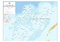
Unofficial NAMRIA map showing features in the Kalayaan Island Group (Spartly Islands). Features names are those recognized by Philippine government.

Related Topics
- South China Sea Arbitration
- Philippines and the Spratly Islands
- Spratly Islands dispute
- Territorial disputes in the South China Sea
See also
 In Spanish: Kalayaan (Palawan) para niños
