
Image: Caledonides EN

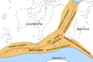
Description: Location of the Caledonian/Acadian mountain chains in the Early Devonian Epoch. Present day coastlines are shown for reference. Red lines are sutures, capitalized names are the different continents/super-terranes that joined during the Caledonian orogeny. See en:Avalonia, en:Baltica, en:Laurentia. Literature used to make this map: Cocks, L.R.M. & Torsvik, T.H.; 2006: European geography in a global context from the Vendian to the end of the Palaeozoic, in: Gee, D.G. & Stephenson, R.A. (eds.): European Lithosphere Dynamics, Geological Society of London Memoirs 32, pp. 83–95. Matte, P.; 2001: The Variscan collage and orogeny (480-290 Ma) and the tectonic definition of the Armorica microplate: a review, Terra Nova 13, 122-128. Stampfli, G.M.; Raumer, J.F. von & Borel, G.D.; 2002: Paleozoic evolution of pre-Variscan terranes: From Gondwana to the Variscan collision, Geological Society of America Special Paper 364, pp. 263-280. Torsvik, T.H.; Smethurst, M.A.; Meert, J.G.; Van der Voo, R.; McKerrow, W.S.; Brasier, M.D.; Sturt, B.A. & Walderhaug, H.J.; 1996: Continental break-up and collision in the Neoproterozoic and Palaeozoic - A tale of Baltica and Laurentia, Earth-Science Reviews 40, p. 229-258. Ziegler, P.A.; 1990: Geological Atlas of Western and Central Europe, Shell Internationale Petroleum Maatschappij BV (2nd ed.), ISBN 90-6644-125-9.
Title: Caledonides EN
Credit: Own work
Author: Woudloper
Usage Terms: Creative Commons Attribution-Share Alike 1.0
License: CC BY-SA 1.0
License Link: http://creativecommons.org/licenses/by-sa/1.0
Attribution Required?: Yes
Image usage
The following 3 pages link to this image:
