
Image: EasternVirginia1775

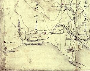
Description: Detail of a 1780s manuscript map depicting the eastern coastal areas of Virginia, including portions of "Princess Anne" and Norfolk counties. The map is oriented with North to the bottom and South to the top. Part of the mouth of Chesapeake Bay is visible at the bottom of the map. The map depicts the sites of several military actions fought on land in the early days of the American Revolutionary War, including w:en:Battle of Kemp's Landing, w:en:Battle of Great Bridge, and the w:en:Burning of Norfolk, and the site of two sea battles of the war, the First and Second Battles of the Capes, the latter also known as w:en:Battle of the Chesapeake.
Title: EasternVirginia1775
Credit: This map is available from the United States Library of Congress's Geography & Map Division under the digital ID g3880.ar144300. This tag does not indicate the copyright status of the attached work. A normal copyright tag is still required. See Commons:Licensing for more information.
Author: Unknown authorUnknown author
Permission: [NP: Request a change in file name, since it contains a contradiction in the date(s) of the map.]
Usage Terms: Public domain
License: Public domain
Attribution Required?: No
Image usage
The following 4 pages link to this image:
