
Image: Etruscan civilization map

Size of this preview: 493 × 599 pixels. Other resolutions: 197 × 240 pixels | 994 × 1,208 pixels.
Original image (994 × 1,208 pixels, file size: 361 KB, MIME type: image/png)
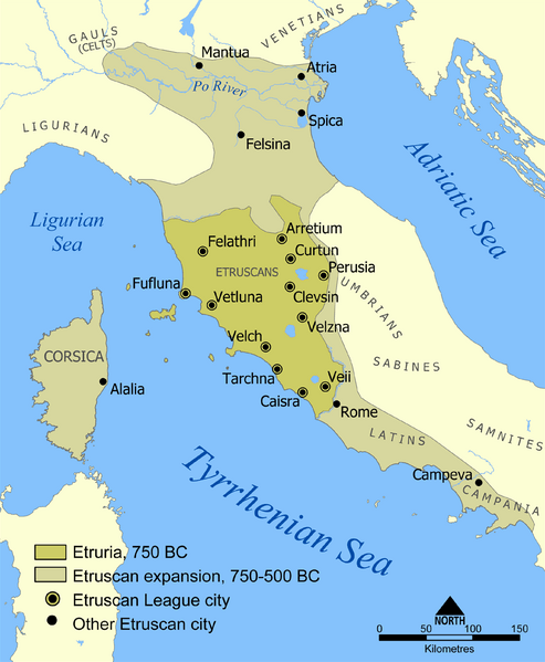
Description: A map showing the extent of Etruria and the Etruscan civilization. The map includes the 12 cities of the Etruscan League and notable cities founded by the Etruscans. The dates on the map are an approximation based on the sources I had. If the article is updated with more accurate dates let me know and I'll modify this map to suit.
Title: Etruscan civilization map
Credit: Based on a map from The National Geographic Magazine Vol.173 No.6 June 1988.
Author: NormanEinstein
Permission: GNU-FDL
Usage Terms: Creative Commons Attribution-Share Alike 3.0
License: CC-BY-SA-3.0
License Link: http://creativecommons.org/licenses/by-sa/3.0/
Attribution Required?: Yes
Image usage
The following 5 pages link to this image:

All content from Kiddle encyclopedia articles (including the article images and facts) can be freely used under Attribution-ShareAlike license, unless stated otherwise.