
Image: LONDON, MARYLEBONE by BARTLETT, F.A. and B.J. DAVIES

Size of this preview: 505 × 600 pixels. Other resolutions: 202 × 240 pixels | 1,684 × 2,000 pixels.
Original image (1,684 × 2,000 pixels, file size: 1.37 MB, MIME type: image/jpeg)
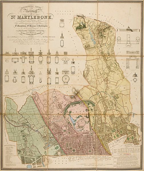
Description: Topographical survey of the borough of St. Marylebone, as incorporated by Act of Parliament 1832, embracing and marking the boundaries of the parishes St. Marylebone, St. Pancras and Paddington. The plan was engraved by B.R. Davies, blank spaces filled with plans and elevations of 20 important buildings, 1145 x 950mm, dated 1834.
Title: LONDON, MARYLEBONE by BARTLETT, F.A. and B.J. DAVIES
Credit: http://www.sothebys.com/en/auctions/ecatalogue/2012/english-literature-history-l12408/lot.14.lotnum.html
Author: J. Britton, J. Taylor & B.R. Davies
Usage Terms: Public domain
License: Public domain
Attribution Required?: No
Image usage
The following 7 pages link to this image:

All content from Kiddle encyclopedia articles (including the article images and facts) can be freely used under Attribution-ShareAlike license, unless stated otherwise.