
Image: Sri Lanka geopolitics - after "Spoiling of Vijayabahu"

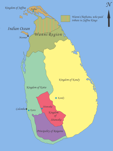
Description: Map showing geopolitical situation in Sri Lanka in the early part of 16th century after the “Spoiling of Vijayabahu” in 1521. Map based on following sources; - “Year 8 History Text Book – Government Publication”, THE ARRIVAL OF THE PORTUGUESE IN SRI LANKA: p14, 06th September 2012. -Fernao de Queyroz. The temporal and spiritual conquest of Ceylon. AES reprint. New Delhi: Asian Educational Services; 1995. p 47-58 ISBN 81-206-0765-1 -Captain Joao Ribeiro. The historic Tragedy of the island of Ceilao. AES Reprint. New Delhi: Asian Educational Services; 1999. p5 ISBN 81-206-1334-1 -Phillipus Baldaeus. A True and Exact Description of the Great Island of Ceylon. English Translation by Pieter Brohier. The Ceylon Historical Journal – Published in Co-operation with the Ceylon Branch of Royal Asiatic Society. Volume III, No 1-4; July 1958 to April 1959. p 300-301 Following maps were used to identify limitations of areas and not for the map itself. -DE L'ISLE:G. - Carte de l'Isle de Ceylan. Published in Paris 1723. http://www.swaen.com/antique-map-of.php?id=1777 , 06 September 2012 - VALENTIJN,F. - Nieuwe Kaart van het Eyland Ceylon opgestelt door. Published in Amsterdam 1724 http://www.swaen.com/antique-map-of.php?id=736
Title: Sri Lanka geopolitics - after "Spoiling of Vijayabahu"
Credit: Own work
Author: Nishadhi
Usage Terms: Creative Commons Attribution-Share Alike 3.0
License: CC BY-SA 3.0
License Link: https://creativecommons.org/licenses/by-sa/3.0
Attribution Required?: Yes
Image usage
The following 3 pages link to this image:
