
Imer, Trentino facts for kids
Quick facts for kids
Imèr
|
|
|---|---|
| Comune di Imer | |
| Country | Italy |
| Region | Trentino-Alto Adige/Südtirol |
| Province | Trentino (TN) |
| Frazioni | Masi di Imèr, Pontet |
| Area | |
| • Total | 27.6 km2 (10.7 sq mi) |
| Elevation | 670 m (2,200 ft) |
| Population
(Dec. 2004)
|
|
| • Total | 1,213 |
| • Density | 43.95/km2 (113.83/sq mi) |
| Demonym(s) | Almeroi or armeroi |
| Time zone | UTC+1 (CET) |
| • Summer (DST) | UTC+2 (CEST) |
| Postal code |
38050
|
| Dialing code | 0439 |
Imèr is a small town, also called a comune, located in Trentino, Italy. It's about 50 kilometers (31 miles) east of Trento, a bigger city in northern Italy. In 2004, about 1,213 people lived there, and the town covered an area of 27.6 square kilometers (10.7 square miles).
Imèr is nestled among beautiful mountains and valleys. It's a great place to learn about Italian village life and enjoy nature.
Contents
Exploring Imèr and Its Surroundings
Imèr is more than just one main village. It includes smaller areas called frazioni, which are like tiny villages or hamlets. These include Masi di Imèr, the village Sass Maor, and Pontet.
Neighboring Towns and Natural Features
Imèr shares its borders with several other towns. These include Primiero San Martino di Castrozza, Canal San Bovo, Mezzano, and Sovramonte.
The area around Imèr is very scenic. It features the Vederne mountain, which is a significant natural landmark. A part of the beautiful Noana valley is also located within the municipality of Imèr.
Population Changes Over Time
The number of people living in Imèr has changed throughout history. For example, in 1921, there were 1,133 residents. The population reached its highest point in 1961 with 1,281 people. By 2001, the population was around 1,134. These numbers show how communities grow and shrink over many years.
Images for kids
-
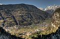
Imèr in Autumn
-
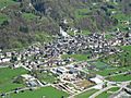
The central part of the village of Imèr
-
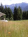
View of the Dolomites from near Imèr


See also
 In Spanish: Imer para niños
