Imperial, Pennsylvania facts for kids
Quick facts for kids
Imperial, Pennsylvania
|
|
|---|---|

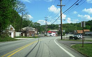
US 30 eastbound in Imperial
|
|

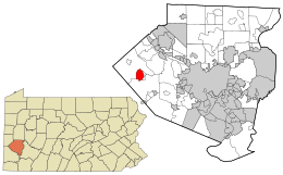
Location in Allegheny County and state of Pennsylvania
|
|
| Country | United States |
| State | Pennsylvania |
| County | Allegheny |
| Townships | Findlay, North Fayette |
| Area | |
| • Total | 3.17 sq mi (8.22 km2) |
| • Land | 3.17 sq mi (8.22 km2) |
| • Water | 0.00 sq mi (0.00 km2) |
| Population
(2020)
|
|
| • Total | 2,722 |
| • Density | 857.86/sq mi (331.27/km2) |
| Time zone | UTC-5 (Eastern (EST)) |
| • Summer (DST) | UTC-4 (EDT) |
| ZIP code |
15126
|
| Area code(s) | 724 |
| FIPS code | 42-36768 |
Imperial is a community in Allegheny County, Pennsylvania, United States. It is known as a census-designated place (CDP). This means it is an area that the government counts for population statistics. Imperial is part of the larger Pittsburgh metropolitan area.
In 2020, about 2,722 people lived in Imperial. The community is located near the Pittsburgh International Airport. It is found within two townships: North Fayette and Findlay.
Contents
History of Imperial
Imperial began as a mining town around 1879. It was founded by the Imperial Coal Company. The town is located along Montour Run, on land that used to be a farm.
At first, the community was called Montour City. But soon, it took the name of the coal company, becoming Imperial. A post office opened in Imperial in 1880. The town and its nearby mines were served by the Montour Railroad.
Imperial used to be part of a larger CDP called Imperial-Enlow. Later, it became its own separate CDP. In 2020, a large Amazon warehouse, called a fulfillment center, opened in Imperial. It is located off of Pennsylvania Route 576.
Geography of Imperial
Imperial is located at coordinates 40.4536 degrees North and 80.2498 degrees West. According to the U.S. Census Bureau, the community covers a total area of about 3.1 square miles (8.2 square kilometers). All of this area is land.
Several important roads provide access to Imperial. U.S. Route 30 goes right through the middle of the area. U.S. Route 22 and Interstate 376 are major highways that connect to roads in Imperial. Also, the partially finished Pennsylvania Route 576 has an exit that serves the community.
People in Imperial
| Historical population | |||
|---|---|---|---|
| Census | Pop. | %± | |
| 2010 | 2,541 | — | |
| 2020 | 2,722 | 7.1% | |
| U.S. Decennial Census | |||
In 2010, the population of Imperial was 2,541 people. Of these, 94 people were born outside the United States. Also, 173 people were military veterans. Most of the population, about 85.9%, had finished high school or continued their education.
The average age of people in Imperial was about 40.9 years old. The median household income was $56,439. This is the middle income for all households in the area. About 6.3% of the population lived below the poverty level.
Education in Imperial
Children living in Imperial attend schools that are part of the West Allegheny School District. The schools that serve the community are:
- Wilson Elementary School – for students in grades K-5
- West Allegheny Middle School – for students in grades 6-8
- West Allegheny Senior High School – for students in grades 9-12
See also
 In Spanish: Imperial (Pensilvania) para niños
 | Charles R. Drew |
 | Benjamin Banneker |
 | Jane C. Wright |
 | Roger Arliner Young |

