
Interstate 296 facts for kids
Quick facts for kids
|
||||
|---|---|---|---|---|
| Lua error in Module:Infobox_road/map at line 15: attempt to index field 'wikibase' (a nil value).
I-296 highlighted in red
|
||||
| Route information | ||||
| Auxiliary route of I-96 | ||||
| Maintained by MDOT | ||||
| Length | 3.393 mi (5.461 km) | |||
| Existed | December 17, 1962–present | |||
| History | Approval granted to remove signage on December 3, 1979 | |||
| Major junctions | ||||
| South end | ||||
| North end | ||||
| Location | ||||
| Counties: | Kent | |||
| Highway system | ||||
| Auxiliary route of the Interstate Highway System Main • Auxiliary • Business Michigan State Trunkline Highway System
|
||||

Interstate 296 (I-296) is a special kind of highway in the United States. It is part of the Interstate Highway System, which connects major cities across the country. This particular highway is located near Grand Rapids, Michigan, in Kent County, Michigan.
I-296 runs for about 3 miles (5 kilometers). It connects Interstate 196 near downtown Grand Rapids with Interstate 96 in Walker, Michigan. For most of its path, it shares its route with U.S. Route 131.
This highway first opened in December 1962. However, if you drive there today, you won't see signs that say "I-296." Instead, the signs only show "U.S. Route 131." Even though the signs are gone, the Interstate 296 designation still exists on maps and in official records.
Images for kids
-
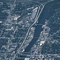
I-296 runs next to the Grand River.
-
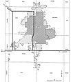
This map from 1955 shows the early plans for highways in the Grand Rapids area.


See also
 In Spanish: Interestatal 296 para niños
