Iroquois Point, Hawaii facts for kids
Quick facts for kids
Iroquois Point
|
|
|---|---|

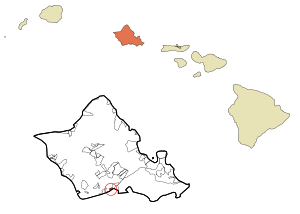
Location in Honolulu County and the state of Hawaii
|
|
| Country | United States |
| State | Hawaii |
| Area | |
| • Total | 1.15 sq mi (2.96 km2) |
| • Land | 0.81 sq mi (2.11 km2) |
| • Water | 0.33 sq mi (0.86 km2) |
| Elevation | 11 ft (3 m) |
| Population
(2020)
|
|
| • Total | 4,549 |
| • Density | 5,595.33/sq mi (2,160.76/km2) |
| Time zone | UTC-10 (Hawaii-Aleutian) |
| ZIP code |
96706
|
| Area code(s) | 808 |
| FIPS code | 15-19100 |
Iroquois Point is a special community located in Honolulu County, Hawaii. It's on the island of Oahu, very close to the famous Pearl Harbor. In 2020, about 4,549 people lived here. Iroquois Point includes homes called Kapilina Beach Homes, a firing range, a Navy store, and an elementary school. It used to be mainly for military families but is now privately owned.
Contents
Where is Iroquois Point?
Iroquois Point is found at specific coordinates: 21°19'46" north and 157°58'51" west. You can get there from North Road in ʻEwa Beach. Another way is by taking Iroquois Point Road from Fort Weaver Road in ʻEwa.
This area covers about 0.6 square miles (1.6 square kilometers) in total. Most of this area, about 0.5 square miles (1.3 square kilometers), is land. The rest, about 0.1 square miles (0.26 square kilometers), is water. So, about 15% of Iroquois Point is water.
Who Lives in Iroquois Point?
| Historical population | |||
|---|---|---|---|
| Census | Pop. | %± | |
| 2020 | 4,549 | — | |
| U.S. Decennial Census | |||
In 2000, there were 2,462 people living in Iroquois Point. There were 675 households, and most of these were families. A large number of households, about 83.6%, had children under 18 living with them. Most families, 95%, were married couples.
The people living here were quite young. About 44.5% of the population was under 18 years old. The average age was 26 years. For every 100 females, there were about 105 males.
A Look Back: History of Iroquois Point
The name Iroquois Point comes from two U.S. Navy ships named USS Iroquois. Both ships had a connection to this area near Pearl Harbor.
The First USS Iroquois
The first USS Iroquois was a steam sloop of war built in 1850. It was used as a hospital ship to care for sailors in Honolulu Harbor. People believe this ship was anchored close to where Iroquois Point is today.
The Second USS Iroquois
The second USS Iroquois was a commercial steam tug boat. It started working for the Navy in 1898. This tugboat helped with operations at Naval Station Honolulu.
World War II and Beyond
During World War II, a group of Navy builders called the Seabees set up a large camp at Iroquois Point. They built areas for thousands of construction workers and also created supply depots. Iroquois Point also had a pier and barracks as part of a larger naval station.
In 2003, the U.S. Navy leased this land to private companies. This was a special deal approved by Congress. In return, the companies agreed to build and repair things on Ford Island. This deal included a 65-year lease for Iroquois Point.
Modern Homes and Airport Views
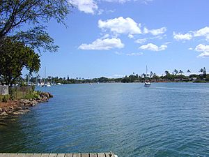
The homes on the north side of Puʻuloa Lagoon were built in the 1960s. They were empty for a while. In 2003, renovations began to update these homes. Many workers helped upgrade hundreds of these houses. Millions of dollars were also spent on new community features, like a community center.
Iroquois Point is located right under the flight path for runway 8L of Honolulu International Airport. This means that people living there often see large commercial and military jets flying low overhead as they land at the airport.
Learning and Schools
The Hawaii Department of Education manages the public schools in Hawaii. Iroquois Point Elementary School is located in this area. Even though it's close by, its official mailing address is in Ewa Beach.
See also
 In Spanish: Iroquois Point para niños
 | John T. Biggers |
 | Thomas Blackshear |
 | Mark Bradford |
 | Beverly Buchanan |


