Isle Madame (Nova Scotia) facts for kids

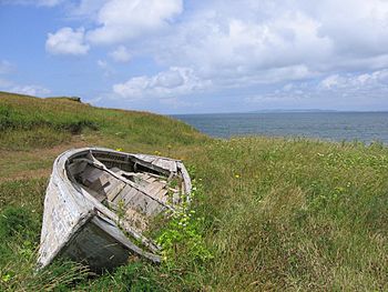
Coastline with derelict dory
|
|
| Geography | |
|---|---|
| Location | near Cape Breton Island |
| Coordinates | 45°33′N 61°00′W / 45.550°N 61.000°W |
| Area | 45 km2 (17 sq mi) |
| Administration | |
|
Canada
|
|
| Province | Nova Scotia |
| Largest settlement | Arichat (pop. 2,000) |
| Demographics | |
| Population | 4,300 (2001) |
| Pop. density | 25 /km2 (65 /sq mi) |
| Ethnic groups | Acadians |
Isle Madame is a Canadian island located in Nova Scotia. It sits off the southeastern tip of Cape Breton Island. This island is a special place with a rich history and strong community ties.
Island History
Isle Madame was first settled by people from France. It was part of their colony called Île-Royale. This area is now known as Cape Breton Island.
The island is believed to be named after Madame de Maintenon. She was the second wife of King Louis XIV of France.
In 1758, many people were forced to leave the area. This happened after the fall of Louisbourg. However, ten Acadian families from Port-Toulouse found a safe place on Isle Madame. Their families still live there today. After a big war, the British took control of Isle Madame. More Acadian families came to the island in 1766. They came from Massachusetts.
Island Size and Location
Isle Madame is about 16 kilometers (10 miles) long. It is also 11 kilometers (7 miles) wide. This gives it a total area of about 45 square kilometers (17 square miles).
The island is part of Richmond County. A narrow waterway called Lennox Passage separates it from Cape Breton Island.
Connecting the Islands
At first, people used ferries to cross Lennox Passage. The first swing bridge was built in 1916. It opened in 1919, connecting Isle Madame to the mainland. There was also a ferry service called the Grandique Ferry.
In the 1970s, an oil spill happened in Chedabucto Bay. To protect the fishing areas, the Government of Nova Scotia built a causeway. This causeway connected Burnt Point and Burnt Island. After the cleanup, the old bridge was taken down. A new bridge and causeway were built. This new structure is called the Burnt Island Bridge.
Isle Madame is also connected to other nearby islands. A bridge connects it to Petit-de-Grat Island. It is also linked by a causeway and bridge to Janvrin Island. Since 1994, the island has had its own community TV station. It is called CIMC-TV, or Telile.
Communities on Isle Madame
About 4,300 people live on Isle Madame. They live in many different communities across the island.
- Alderney Point
- Arichat
- Boudreauville
- Cape Auguet
- Cap La Ronde
- D'Escousse
- Lennox
- Lochside
- Martinique
- Little Anse
- Petit de Grat
- Poirierville
- Pondville
- Pondville South
- Port Royal
- Poulamon
- Rocky Bay
- Samson's Cove
- St. Marys
- West Arichat
 | Kyle Baker |
 | Joseph Yoakum |
 | Laura Wheeler Waring |
 | Henry Ossawa Tanner |


