Isle of Wight Bay facts for kids
Quick facts for kids Isle of Wight Bay |
|
|---|---|
| Location | Worcester County, Maryland |
| Coordinates | 38°22′18″N 75°05′51″W / 38.37167°N 75.09750°W |
| Type | Bay |
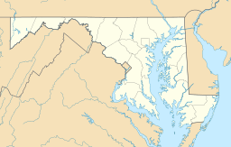
The Isle of Wight Bay is a cool body of water located in Worcester County, Maryland. It's a special type of bay known as a lagoon. This bay plays an important role in the local geography. It separates a part of the mainland from the midtown area of Ocean City.
Contents
Exploring Isle of Wight Bay
The Isle of Wight Bay is a unique natural feature. It is a long, narrow body of water. It stretches along the coast of Maryland. This bay is a popular spot for many activities.
What is a Lagoon?
A lagoon is a shallow body of water. It is often separated from a larger body of water, like an ocean. This separation is usually by a narrow strip of land. In the case of Isle of Wight Bay, it's separated from the Atlantic Ocean. This makes it a calm and protected area.
Where is the Bay Located?
The Isle of Wight Bay is found in Worcester County, Maryland. It lies between the mainland and the barrier island where Ocean City is built. This location makes it a key part of the coastal environment. It's a busy area, especially during summer.
Connections to Other Bays
The Isle of Wight Bay is not alone. It connects to other bays nearby. To the north, it links up with the Assawoman Bay. This connection is just south of the Assawoman Bay Bridge. To the south, it joins the Sinepuxent Bay. This southern connection is near the northern end of West Ocean City. The bay becomes narrower here. It narrows between a channel called Thoroughfare and Mallard Island.
Rivers Flowing into the Bay
Several rivers and creeks flow into the Isle of Wight Bay. These waterways bring fresh water into the bay. The main river that feeds into the bay is the St. Martin's River. Other important waterways include Turville Creek, Manklin Creek, and Herring Creek. These tributaries help keep the bay's ecosystem healthy.
 | Laphonza Butler |
 | Daisy Bates |
 | Elizabeth Piper Ensley |


