
Sinepuxent Bay facts for kids
Quick facts for kids Sinepuxent Bay |
|
|---|---|

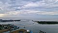
The Sinepuxent Bay crossed by the Harry W. Kelley Memorial Bridge, looking south. The southern end of Ocean City, the Ocean City Inlet, the northern tip of Assateague Island, the south inlet jetty, and the Atlantic Ocean are at the top of the image. Skimmer Island is in the left-center and Horn Island is in the right center of the picture, in front of the bridge.
|
|

Sinepuxent Bay
Location in Maryland
|
|
| Location | Worcester County, Maryland |
| Coordinates | 38°15′00″N 75°08′39″W / 38.25000°N 75.14417°W |
| Type | Bay |
| Surface elevation | 0 feet (0 m) |
Sinepuxent Bay is a beautiful waterway located in Worcester County, Maryland. It's like a natural channel that connects Chincoteague Bay to Isle of Wight Bay. The bay also links up with the Atlantic Ocean through the Ocean City Inlet.
This bay acts as a natural border. It separates an area called Sinepuxent Neck from Assateague Island. It also divides West Ocean City, Maryland from downtown Ocean City. Inside the bay, you can find small land masses like Horn Island and Skimmer Island.
Two important bridges cross Sinepuxent Bay. The Harry W. Kelley Memorial Bridge carries U.S. Route 50. The Verrazano Bridge is part of Maryland Route 611. Both bridges are named after Giovanni da Verrazzano, an explorer who mapped the coastline in 1524. The bay is also home to the Sinepuxent Bay Wildlife Management Area, which protects local wildlife.
The Old Sinepuxent Inlet
For a long time, there was a natural opening called the Sinepuxent Inlet. This inlet allowed boats to pass through the barrier island to the ocean. It was located just south of the Assateague Island National Seashore day-use area.
In September 1698, a French pirate named Canoot captured a boat. This happened as the boat was leaving the old Sinepuxent Inlet. However, this inlet did not last forever. A strong hurricane in 1818 closed the inlet. By 1860, sand had completely filled it in.
The hurricane also destroyed a community called Sinepuxent. This town was on the mainland, about half a mile north of where the Verrazano Bridge is today.
The Modern Ocean City Inlet
The inlet we see today is called the Ocean City Inlet. It was created by a very powerful storm. This storm was the great 1933 Chesapeake–Potomac hurricane, which hit in 1933.
After the hurricane, the United States Army Corps of Engineers started working. They built strong rock jetties to keep the new inlet open. This work began in October 1933.
Because of this new inlet, the way water flows in the bays changed. Now, the United States Army Corps of Engineers considers the Isle of Wight Bay to reach south to the inlet. They define Sinepuxent Bay as extending south from the inlet to Chincoteague Bay. This is a bit different from how the bays were named in the past.
Images for kids
-

Arthur Quartley, On Synepuxent Bay, Maryland 1876. Brooklyn Museum
-
Ocean City Maryland Inlet


