Jácana, Yauco, Puerto Rico facts for kids
Quick facts for kids
Jácana
|
|
|---|---|
|
Barrio
|
|

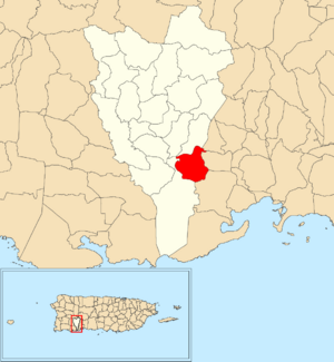
Location of Jácana within the municipality of Yauco shown in red
|
|
| Commonwealth | |
| Municipality | |
| Area | |
| • Total | 2.48 sq mi (6.4 km2) |
| • Land | 2.48 sq mi (6.4 km2) |
| • Water | 0 sq mi (0 km2) |
| Elevation | 128 ft (39 m) |
| Population
(2010)
|
|
| • Total | 1,690 |
| • Density | 681.5/sq mi (263.1/km2) |
| Source: 2010 Census | |
| Time zone | UTC−4 (AST) |
Jácana is a special kind of neighborhood, called a barrio, located in the town of Yauco, Puerto Rico. In 2010, about 1,690 people lived there. It's a part of the beautiful island of Puerto Rico.
Where is Jácana?
Jácana is found within the municipality of Yauco. A municipality is like a county or a large town area. Yauco is on the southwestern side of Puerto Rico. Jácana itself covers an area of about 2.48 square miles (6.42 square kilometers). It sits at an elevation of about 128 feet (39 meters) above sea level.
How Many People Live Here?
The number of people living in Jácana changes over time. Here's a look at its population from different years:
| Historical population | |||
|---|---|---|---|
| Census | Pop. | %± | |
| 1980 | 1,742 | — | |
| 1990 | 1,667 | −4.3% | |
| 2000 | 1,969 | 18.1% | |
| 2010 | 1,690 | −14.2% | |
| U.S. Decennial Census 1899 (shown as 1900) 1910-1930 1930-1950 1980-2000 2010 |
|||
As you can see, the population has gone up and down over the years. In 2010, it was 1,690 people.
See also
 In Spanish: Jácana para niños
- List of communities in Puerto Rico
Black History Month on Kiddle
Famous African-American Artists:
 | Delilah Pierce |
 | Gordon Parks |
 | Augusta Savage |
 | Charles Ethan Porter |

All content from Kiddle encyclopedia articles (including the article images and facts) can be freely used under Attribution-ShareAlike license, unless stated otherwise. Cite this article:
Jácana, Yauco, Puerto Rico Facts for Kids. Kiddle Encyclopedia.

