Jambaló facts for kids
Quick facts for kids
Jambaló
Jambaló
|
|||
|---|---|---|---|
|
Municipality and town
|
|||
 |
|||
|
|||

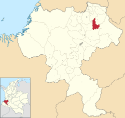
Location of the municipality and town of Jambaló in the Cauca Department of Colombia.
|
|||
| Country | |||
| Department | Cauca Department | ||
| Area | |||
| • Total | 254 km2 (98 sq mi) | ||
| Population
(Census 2018)
|
|||
| • Total | 16,353 | ||
| • Density | 64.38/km2 (166.7/sq mi) | ||
| Time zone | UTC-5 (Colombia Standard Time) | ||
| Climate | Cfb | ||
| Website | http://www.jambalo-cauca.gov.co | ||
Jambaló is a special place in Colombia. It is both a municipality (like a county or district) and an indigenous reservation. This means it's a specific area where native people live and have their own rules.
Jambaló is located in the northeastern part of the Cauca Department. It is about 80 kilometers (50 miles) north of Popayán, which is the capital city of the department.
Where is Jambaló?
Jambaló shares its borders with several other towns. To the north, it is next to Caloto and Toribío. To the east, you will find Páez. Silvia is to the south, and Caldono and Santander de Quilichao are to the west.
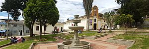
The main town of Jambaló is also called "Jambaló." It is the most populated area and is located in the very south, near the border with Silvia. However, most people (about 94%) live in the rural areas outside the main town.
Who Lives in Jambaló?
Since Jambaló is also an indigenous reservation, most of its people belong to native groups. The main groups living here are the Nasa and Misak people. They have their own cultures and traditions.
How Many People Live There?
According to a census from 2018, about 16,353 people live in Jambaló. This number includes both the people in the main town and those in the surrounding rural areas.
Climate
Jambaló has a type of climate called Cfb. This means it usually has mild temperatures and rainfall throughout the year. It is a comfortable climate for living and growing crops.
See also
 In Spanish: Jambaló para niños
 | Claudette Colvin |
 | Myrlie Evers-Williams |
 | Alberta Odell Jones |


