Quick facts for kids Jane Peak |
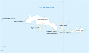
Location in South Orkney Islands
|
| Coordinates |
60°43′S 45°38′W / 60.717°S 45.633°W / -60.717; -45.633 |
Jane Peak is a noticeable nunatak in the South Orkney Islands. A nunatak is a rocky peak that sticks out above a glacier or ice sheet. Jane Peak is about 210 metres (700 ft) tall. It stands about 0.5 nautical miles (1 km) west of the northern part of Borge Bay on Signy Island.
Exploring Jane Peak
Jane Peak was first roughly mapped in 1933. This mapping was done by people working for Discovery Investigations. Later, in 1947, the Falkland Islands Dependencies Survey mapped it again more carefully.
How Jane Peak Got Its Name
The peak was officially named in 1954. The UK Antarctic Place-Names Committee gave it its name. They named it after a ship called the Jane. This ship was a brig, which is a type of sailing vessel. The Jane was led by James Weddell. It visited the South Orkney Islands in 1822 and 1823.


