Janesville, Pennsylvania facts for kids
Quick facts for kids
Janesville, Pennsylvania
|
|
|---|---|
|
Unincorporated community
|
|
| Country | United States |
| State | Pennsylvania |
| County | Clearfield |
| Elevation | 1,545 ft (471 m) |
| Time zone | UTC-5 (Eastern (EST)) |
| • Summer (DST) | UTC-4 (EDT) |
| ZIP code |
16680
|
| Area code(s) | 814 |
| GNIS feature ID | 1177990 |
Janesville, also known as Smithmill, is a small community in Clearfield County, Pennsylvania, United States. It is not a city or a town with its own local government. Instead, it is an "unincorporated community." This means it is part of a larger township or county.
Contents
What is an Unincorporated Community?
An unincorporated community is a place where people live. It does not have its own separate government. For example, it won't have its own mayor or town council.
How it Works
Services like roads, schools, and police are usually managed by the larger county or township. This is different from a city or borough, which has its own elected officials.
Where is Janesville Located?
Janesville is found in central Pennsylvania. It is about 2.9 miles (4.7 km) south-southwest of a place called Ramey.
Important Roads
The community is easy to find. It sits right where three state routes meet. These roads are Route 253, Route 453, and Route 729.
Janesville's Post Office
Janesville has its own post office. It uses the ZIP code 16680. This post office has been serving the community for a very long time. It first opened its doors on February 25, 1826.
A Look at the Past
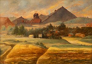
The image of the Janesville Breaker from 1919 shows a part of the area's history. A "breaker" was a building used in coal mining. It would break up coal into different sizes. This suggests that coal mining was once an important industry in the Janesville area.


