Jatibonico del Sur River facts for kids
Quick facts for kids Jatibonico del Sur |
|
|---|---|

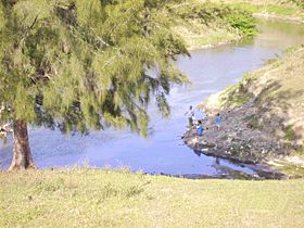
Fishermen at the Jatibonico del Sur
|
|
|
Location of mouth
|
|
| Country | Cuba |
| Physical characteristics | |
| Main source | Santa Clara 220 m (720 ft) 22°13′N 79°14′W / 22.217°N 79.233°W |
| River mouth | Atlantic Ocean Jatibonico 0 m (0 ft) (Sea level) 21°33′N 79°09′W / 21.550°N 79.150°W |
| Length | 119.5 km (74.3 mi) |
The Río Jatibonico del Sur is an important river in southern Cuba. It plays a big role in the lives of people living nearby.
Contents
Where the River Starts
This river begins its journey about 1 kilometre (0.6 miles) south of a town called Iguará. It starts high up, at an elevation of 220 metres (720 feet). From there, the water flows down from the hills of Santa Clara.
The river actually splits into two main streams. The southern stream is the Río Jatibonico del Sur, which is what we are learning about. The northern stream is called the Río Jatibonico del Norte.
Where the River Ends
The Río Jatibonico del Sur flows all the way to the Atlantic Ocean. Its mouth, or where it meets the ocean, is located at the tip of Jatibonico. This area is low and a bit marshy. It's about 15 kilometres (9.3 miles) south of the town El Jíbaro.
River's Length and Borders
The river is quite long, stretching for 119.5 kilometres (74.3 miles). It forms a natural border between several areas. For example, it separates the municipalities of Taguasco and Jatibonico. It also marks the border between Jatibonico and La Sierpe.
How People Use the River
The water from the Río Jatibonico del Sur is very important for farming. Farmers use it to water their crops, especially large fields of rice. This helps to grow food for many people.
See also
 In Spanish: Río Jatibonico del Sur para niños
 | May Edward Chinn |
 | Rebecca Cole |
 | Alexa Canady |
 | Dorothy Lavinia Brown |


