Taguasco facts for kids
Quick facts for kids
Taguasco
|
|
|---|---|
 |
|

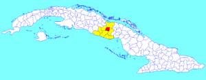
Taguasco municipality (red) within
Sancti Spíritus Province (yellow) and Cuba |
|
| Country | Cuba |
| Province | Sancti Spíritus |
| Area | |
| • Total | 518 km2 (200 sq mi) |
| Elevation | 100 m (300 ft) |
| Population
(2022)
|
|
| • Total | 32,968 |
| • Density | 63.64/km2 (164.84/sq mi) |
| Time zone | UTC-5 (EST) |
| Area code(s) | +53-41 |
| Website | https://taguasco.gob.cu/ |
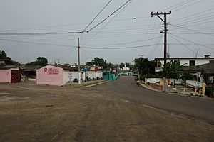
Taguasco is a town and a special area called a municipality in Cuba. It is located in the Sancti Spíritus Province, which is one of Cuba's provinces. Think of a municipality as a local government area, like a county or district.
Contents
Exploring Taguasco's Location
Taguasco is found about 20 kilometers (that's about 12 miles) northeast of Sancti Spiritus. Sancti Spiritus is the capital city of the province. Imagine Taguasco as a neighbor to the main city.
Important Roads in Taguasco
A very important road called the Carretera Central highway goes right through Taguasco. This highway connects many towns and cities across Cuba. It helps people travel easily between places like Cabaiguán and Jatibonico.
People and Area of Taguasco
How Many People Live Here?
In 2022, the municipality of Taguasco had a population of 32,968 people. This number tells us how many residents call Taguasco home.
Understanding Taguasco's Size
The total area of Taguasco is about 518 square kilometers (which is about 200 square miles). To give you an idea of how many people live in each part of the land, we look at something called population density. Taguasco has a population density of about 64 people per square kilometer. This means, on average, 64 people live in every square kilometer of land.
See also
 In Spanish: Taguasco para niños
 | Sharif Bey |
 | Hale Woodruff |
 | Richmond Barthé |
 | Purvis Young |

