Jericho Village Historic District facts for kids
Quick facts for kids |
|
|
Jericho Village Historic District
|
|
 |
|
| Location | VT 15, Plains Rd., Mill St. and Old Pump Rd., Jericho, Vermont |
|---|---|
| Area | 96 acres (39 ha) |
| Built | 1858 |
| Architectural style | Greek Revival, Italianate, Federal |
| NRHP reference No. | 92001533 |
| Added to NRHP | November 5, 1992 |
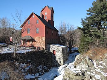
The Jericho Village Historic District is a special area in Jericho (village), Vermont. It's where the town's old factories and shops used to be. This district is found along Vermont Route 15, near the Browns River. The river was very important because it powered many of the village's early businesses. This area has many buildings from the 1800s and early 1900s that are still in great shape. In 1992, this district was added to the National Register of Historic Places, which means it's a very important historical site.
Exploring Jericho Village's Past
How Jericho Village Grew
The village of Jericho started in the early 1800s. It grew around several mills located on the Browns River. In the first half of the 19th century, these mills mostly cut wood (sawmills) and ground grain (gristmills).
Around the 1820s, the mills began to make woolen cloth. Later in the 1800s, the river's power was used for many other types of factories. These businesses used the natural resources found in the area.
In the early 1900s, the water-powered industries started to slow down. Most of the old factory buildings were taken down or destroyed by fires or floods. Fires also sometimes swept through other parts of the village. However, many important buildings from the 1800s are still standing today.
What You'll See in the District
The historic district follows Vermont Route 15. This road is called Main Street in the western part and Church Street in the eastern part. These two roads meet at a small triangle-shaped park. From this park, Lee River Road and Plains Road stretch out to the south.
The district's western edge is near Lawrence Heights. Its eastern edge is roughly Griswold Street. Besides the buildings on Church and Main Streets, the district also includes properties on Lee River Road, Plains Road, and Old Pump Road.
You can also find the remains of the old mill areas on both sides of the Browns River. The river runs mostly parallel to Route 15. Most of the buildings in the district are made of wood. However, there are a few important exceptions. These include the brick Congregational Church, built in 1826, and the Galusha House, built in 1790.
The village's industrial past is still very clear at the Old Red Mill and Mill House. This building is also known as the Chittenden Mill. It's located at the western end of the historic district. Today, it's a museum run by the local historical society. It helps people learn about Jericho's history.
 | Aaron Henry |
 | T. R. M. Howard |
 | Jesse Jackson |


