Jesús de Machaca Municipality facts for kids
Quick facts for kids
Jesús de Machaca Municipality
|
|
|---|---|
|
Municipality
|
|

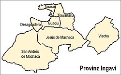
Location of the municipality within Ingavi province
|
|
| Country | |
| Department | La Paz Department |
| Province | Ingavi Province |
| Seat | Jesús de Machaca |
| Area | |
| • Total | 369 sq mi (955 km2) |
| Population
(2001)
|
|
| • Total | 13,247 |
| Time zone | UTC-4 (BOT) |
The Jesús de Machaca Municipality is a special area in Bolivia, like a local government district. It's the sixth municipality in the Ingavi Province, which is part of the La Paz Department. This municipality was officially created on May 7, 2002, during the time Jorge Quiroga Ramírez was president. The main town, or 'seat,' of this municipality is called Jesús de Machaca.
Contents
Where is Jesús de Machaca?
Jesús de Machaca Municipality is located in Bolivia, south of the famous Lake Titicaca. It's also home to the Chilla-Kimsa Chata mountain range, which runs through the area. This means you can find many tall mountains here!
Tall Mountains in the Area
Some of the highest mountains you can find in the municipality include:
- Achachi Qala
- Apachita
- Asir Kunka
- Chuqi Ch'iwani
- Chuqi Q'awa
- Chuqi Q'awa (Chuñuni Jawira)
- Chhuxlla Willk'i
- Ch'alla Qullu
- Ch'utu Wankarani
- Imill Wawani
- Jach'a Uma Chuwani
- Jani Lawani
- Jisk'a Sallalla
- Laqaya
- Pukara
- Phujtir Pata Punta
- Q'awiri Qullu
- Q'ilani
- Q'ullq'uni
- Turini
- T'aqachiri
- Wayllani
- Wanq'uni
- Wila Qullu
- Wisk'achani
How the Municipality is Divided
The Jesús de Machaca Municipality is split into ten smaller areas called cantons. Each canton has its own communities and people.
Cantons and Their Populations
Here are the ten cantons and how many people lived in each one in 2001:
- Aguallamaya - 1,694 people
- Chama - 1,278 people
- Cuipa España de Machaca - 662 people
- Jesús de Machaca - 862 people
- Kalla Tupac Katari - 2,669 people
- Khonkho San Salvador - 755 people
- Mejillones de Machaca - 845 people
- Santa Ana de Machaca - 363 people
- Santo Domingo de Machaca - 588 people
- Villa Asunción de Machaca - 3,244 people
The People of Jesús de Machaca
Most of the people living in Jesús de Machaca Municipality are indigenous citizens. Many of them are from the Aymara group.
Ethnic Groups in the Municipality
Here's a look at the different ethnic groups found in the municipality:
| Ethnic Group | Percentage |
|---|---|
| Quechua | 0.3 |
| Aymara | 94.4 |
| Guaraní, Chiquitos, Moxos | 0.1 |
| Not indigenous | 4.3 |
| Other indigenous groups | 0.9 |
Cool Places to Visit
The municipality has some interesting places that visitors might enjoy:
- The ancient archaeological site of Qhunqhu Wankani in Jesús de Machaca Canton. It's a place with old ruins and history.
- The community of Jesús de Machaca itself, which is an important indigenous community.
- The Yakayuni salt flats, also in Jesús de Machaca Canton. Here, people can collect salt.
- The Uru Iruito community and the Urus Iruito museum, both in Jesús de Machaca Canton. This museum teaches about the Uru Iruito people.
See also
 In Spanish: Jesús de Machaca para niños
 | Charles R. Drew |
 | Benjamin Banneker |
 | Jane C. Wright |
 | Roger Arliner Young |


