Jobabo facts for kids
Quick facts for kids
Jobabo
|
|
|---|---|

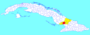
Jobabo municipality (red) within
Las Tunas Province (yellow) and Cuba |
|
| Country | Cuba |
| Province | Las Tunas |
| Area | |
| • Total | 884 km2 (341 sq mi) |
| Elevation | 50 m (160 ft) |
| Population
(2022)
|
|
| • Total | 40,345 |
| • Density | 45.639/km2 (118.20/sq mi) |
| Time zone | UTC-5 (EST) |
| Area code(s) | +53-31 |
| Website | https://www.jobabo.gob.cu/ |
Jobabo is a town and a special area called a municipality in the Las Tunas Province of Cuba. It is located in the southern part of the province. Jobabo is about 34 kilometers (21 miles) south of Las Tunas, which is the capital city of the province.
What's in a Name?
The name Jobabo comes from an old word in the Taíno language. The Taíno people were the original inhabitants of the Caribbean islands, including Cuba. The word jobabol meant "a place where many jobo trees grow." So, Jobabo is named after a type of tree that was common in the area.
People and Land
How Many People Live Here?
In 2022, about 40,345 people lived in the municipality of Jobabo. This number tells us how many residents call Jobabo home.
How Big is Jobabo?
The total area of Jobabo is about 884 square kilometers (341 square miles). To understand how many people live in each part of the land, we look at something called population density. In Jobabo, there are about 46 people living in every square kilometer (about 119 people per square mile). This helps us imagine how spread out or close together the homes are.
See also
 In Spanish: Jobabo para niños
 | William Lucy |
 | Charles Hayes |
 | Cleveland Robinson |

