Juárez, Nuevo León facts for kids
Quick facts for kids
Ciudad Benito Juárez
|
||
|---|---|---|
|
||
| Motto(s):
El respeto al derecho ajeno es la paz (Respect to other's rights, is peace)
|
||
 |
||
| Country | Mexico | |
| State | Nuevo León | |
| Founded | June 15, 1604 | |
| Area | ||
| • City | 39.32 km2 (15.18 sq mi) | |
| Elevation | 403 m (1,322 ft) | |
| Population
(2020 census)
|
||
| • City | 308,285 | |
| • Density | 7,840.4/km2 (20,306.6/sq mi) | |
| • Metro | 5,341,177 | |
| Time zone | UTC-6 (Central Standard Time) | |
| • Summer (DST) | UTC-5 (Central Daylight Time) | |
| Website | http://juarez-nl.gob.mx | |
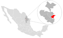
Ciudad Benito Juárez, often just called Juárez, is a lively city in Mexico. It's located in the eastern part of the Monterrey metropolitan area in the state of Nuevo León. Juárez is the main city of its own local government area, also called a municipality.
In 2020, about 308,285 people lived in Ciudad Benito Juárez. This makes it the sixth-largest city in Nuevo León. The city shares its borders with other municipalities. To the north is Pesquería, to the south is Santiago, to the east is Cadereyta Jiménez, and to the west is Guadalupe.
Contents
How Juárez Got Its Name
The city was named to honor a very important person in Mexican history. It's named after Benito Juárez, who was a Mexican president in the 1800s.
A Look at Juárez's Past
Juárez has a long history, starting way back in 1604.
- Early Days: The area was first known as "Hacienda de San José" or "Hacienda San José de los González." It was founded on June 15, 1604.
- Land Grant: On April 1, 1642, Martín de Zavala, who was the governor of Nuevo León, officially gave the land to Bernabé González Hidalgo for settlement.
- New District: On March 1, 1850, the state government created a new district called "El Rosario." This district was part of the larger Cadereyta municipality until 1868.
- Becoming a Village: On December 30, 1868, General Jerónimo Treviño, the governor at the time, declared that "Villa de Juárez" (Juarez's Village) would be founded in the same area as "El Rosario." Many villages like this were created in the 1800s to use the natural resources of the region.
- Reaching City Status: Finally, in May 1988, Villa de Juárez was given the title of a city. It was officially named "Ciudad Benito Juárez."
Juárez Today: A Growing City
Today, Ciudad Benito Juárez is growing very fast. Many new houses and neighborhoods are being built. This is happening because other cities in the Monterrey metropolitan area are running out of space for new homes.
Geography and Climate
The municipality of Juárez covers an area of about 277.8 square kilometers (about 107 square miles). It sits at an elevation of 403 meters (about 1,322 feet) above sea level.
- Landscape: Most of the land, about 70%, is flat or gently sloping. The other 30% is more rugged and mountainous, but without very tall peaks.
- Rivers: The area has rivers flowing through it. The La Silla River crosses the land and meets the Santa Catarina River at a place called "Las adjuntas." The La Silla River then joins the San Juan River in the nearby municipality of Cadereyta Jiménez.
Weather in Juárez
Juárez has a dry and hot climate, known as BSH. The average temperature throughout the year is about 22 degrees Celsius (72 degrees Fahrenheit). The city receives about 400 millimeters (15.7 inches) of rain each year. The winds usually come from the north.
See also

- In Spanish: Ciudad Benito Juárez para niños
 | Toni Morrison |
 | Barack Obama |
 | Martin Luther King Jr. |
 | Ralph Bunche |


