Jubaland facts for kids
Quick facts for kids
Jubaland State of Somalia
|
|
|---|---|

Location of Jubaland
|
|
| Capital | Bu'ale (de jure) Kismayo (de facto) |
| Largest city | Kismayo |
| Official languages | |
| Demonym(s) | Somali |
| Government | Federated state under a presidential democracy |
|
• President
|
Ahmed Madobe |
|
• Vice President
|
Mohamud Sayid Aden |
| Federal Member State
within Somalia
|
|
| Area | |
|
• Total
|
110,293 km2 (42,584 sq mi) |
|
• Water (%)
|
negligible |
| Population | |
|
• 2014 estimate
|
3,360,633 |
| Currency | Somali shilling (SOS) |
| Time zone | UTC+3 (EAT) |
|
• Summer (DST)
|
UTC+3 (not observed) |
| Calling code | +252 (Somalia) |
| ISO 3166 code | SO |
| Internet TLD | .so |
|
Federal States in Somalia
|
|
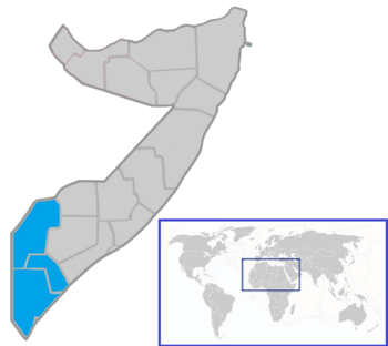
Jubaland (also called the Juba Valley) is a special region in southern Somalia. It is known as a Federal Member State within the country. The Jubba River flows through it, reaching the Indian Ocean. To the west, Jubaland shares a border with Kenya.
Jubaland covers an area of about 110,293 square kilometers (42,584 square miles). In 2005, it had a population of around 953,045 people. The biggest city is Kismayo, located right on the coast of the Indian Ocean. Other important towns include Bardhere, Luuq, and Beled Haawo.
Long ago, powerful Somali kingdoms like the Ajuran Sultanate and the Geledi Sultanate ruled this land. Later, it became part of British East Africa. In 1925, Jubaland was given to Italy and became part of Italian Somaliland. Finally, on July 1, 1960, Jubaland joined the rest of Italian Somaliland and British Somaliland to form the independent Somali Republic.
Contents
History of Jubaland
During the Middle Ages, the strong Ajuran Empire controlled the area we now call Jubaland. After them, the Geledi Sultanate took over in more recent times.
From 1836 to 1861, parts of Jubaland were also claimed by the Sultanate of Muscat, which is now part of Oman.
Colonial Rule
The Geledi Sultanate, which ruled this whole region, later joined the Italian Somaliland protectorate. This happened after the Geledi ruler, Osman Ahmed, signed agreements with the Italian colonial powers.
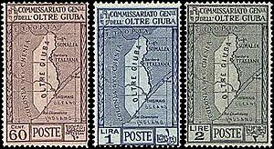
Jubaland was then given to Italy in 1924–1925. This was a reward because Italy had joined the Allies in World War I. For a short time, it was an Italian colony called Trans-Juba (Oltre Giuba). Italy even made special stamps for the area in 1925. Britain kept control of the southern part of Jubaland, which became known as the Northern Frontier District (NFD).
Jubaland officially became part of Italian Somaliland on June 30, 1926. The border with Kenya was decided by special commissions.
Resettlement in 1974
After Somalia became independent, many people from other parts of the country moved to the Jubba regions. This was a big event in the area's history.
Between 1974 and 1975, a severe drought hit northern Somalia. It was called the Abaartii Dabadheer or "The Lingering Drought." The Soviet Union helped by flying about 90,000 people from the affected areas to new settlements in the Jubbada Hoose (Lower Jubba) and Jubbada Dhexe (Middle Jubba) regions. These new places were called Danwadaagaha ("Collective Settlements"). The families who moved there learned new skills like farming and fishing, which was different from their usual life of herding animals.
Forming the Jubaland Administration
In 2011, the Kenyan military entered Somalia. At first, Somalia's President Sharif Ahmed was unsure about this. However, the Somali and Kenyan governments later agreed to work together on the mission.
The new President of Somalia, Hassan Sheikh Mohamoud, and his government initially said that forming Jubaland was against the country's laws. They wanted the process to wait until parliament set up rules for new regional states. But the people organizing the Jubaland conference did not agree to wait.
Discussions to reach an agreement among different clans began in late 2011. On February 28, 2013, over 500 representatives met in Kismayo for a conference to plan the creation of Jubaland. They set up a committee to manage the process. Many important politicians attended the meeting.
On April 2, 2013, the delegates at the Kismayo conference approved a draft constitution for Jubaland. Then, on May 15, 2013, a large majority of the delegates elected Ahmed Mohamed Islam (Madobe) as the President of Jubaland.
On August 28, 2013, the new Jubaland administration signed an agreement with the Federal Government of Somalia in Addis Ababa. This agreement was helped by Ethiopia. Under the agreement, Jubaland would be managed for two years by an interim administration led by President Ahmed Mohamed Islam. He would also choose three deputies. The management of Kismayo's seaport and airport would be given to the Federal Government after six months. The money from these places would be used for Jubaland's services, security, and local development. Also, Jubaland's military forces would join the Somali National Army. Many international groups praised this agreement as a big step for Somalia's future.
On September 16, 2014, President Hassan Sheikh Mohamud officially opened a meeting in Kismayo to help different groups in Jubaland work together.
On December 30, 2014, President Ahmed Mohamed Islam of Jubaland and President Sharif Hassan Sheikh Adan of South West State signed an agreement. This agreement covered topics like federalism, security, elections, trade, and the constitution. They agreed on fair sharing of international aid and on old border lines. They also suggested that the federal government should give more power to regional bodies. Both states also decided to form a security committee to work together on fighting crime and sharing information. They also wanted to create a commission to connect the federal government with the regional states.
In February 2015, the Interim Juba Administration started choosing members for its new regional parliament. On April 15, 2015, a new 75-seat parliament was officially opened in Kismayo. On May 7, 2015, a ceremony was held for the first regional parliament of Jubaland. Many important people attended, including the President of Somalia and foreign ministers from Kenya and Ethiopia.
On May 20, 2015, Jubaland's new regional cabinet changed some of its ministers.
Borders of Jubaland
Jubaland has a total border length of about 1,500 kilometers (930 miles). This includes land borders with other regions and countries, as well as its coastline along the Indian Ocean.
- The northern border, shared with the Southwest State, is 450 km (280 miles) long.
- The southwestern border with Kenya, which generally follows the Jubba River, is about 300 km (190 miles) long.
- The northwestern border with Ethiopia is roughly 200 km (125 miles) long.
- The eastern border, shared with the Southwest State, is 150 km (93 miles) long.
- The eastern coastline of Jubaland along the Indian Ocean is about 400 km (250 miles) long.
Border Issues with Kenya
In February 2019, Kenyan officials said that Somalia was improperly selling rights to drill for oil and gas off the coast of Jubaland. The International Court of Justice (ICJ) was set to hear a case about these ocean borders in September 2019. Kenya wanted Somalia to drop the ICJ case and talk about it directly, but Somalia saw this as a delay tactic. Kenya had given drilling rights to French and Italian companies in 2009, but then accused Somalia of doing the same. Somalia denied this. In 2020, Somalia won most of its case at the ICJ regarding the maritime border off the Jubaland coast.
People of Jubaland
Jubaland has a total population of about 2.5 million people. Most of the people living here are from the Somali ethnic group.
Transportation
Jubaland has several airports for air travel. These include:
- Bardera Airport (IATA: BSY, ICAO: HCMD) serves Bardera. It is 168 meters (550 feet) above sea level and has one runway made of compacted sand.
- Garbaharey Airport (IATA: GBM) serves Garbaharey. Its runway is 1,050 meters (3,445 feet) long.
- Lugh Ganane Airport (IATA: LGX, ICAO: HCMJ) serves Luuq. Its runway is 1,120 meters (3,675 feet) long.
- Kismayo Airport (IATA: KMU, ICAO: HCMK) serves Kismayo. It is 15 meters (49 feet) above sea level and has one asphalt runway that is 3,688 meters (12,100 feet) long.
Districts in Jubaland
Here is a list of the districts in Jubaland and their estimated populations in 2023:
| District | Population (2023 Approximations) |
|---|---|
| Bardere | 470,000 |
| Kismayo | 630,708 |
| Jamame | 104,571 |
| Dolow | 101,519 |
| Elwak | 151,773 |
| Badhadhe | 83,729 |
| Bu'ale | 70,209 |
| Baladhawo | 100,635 |
| Luuq | 286,402 |
| Jilib | 121,894 |
| Sakow | 45,454 |
| Burdhubo | 111,550 |
| Afmadow | 109,954 |
| Garbaharey | 167,252 |
| Dhobley | 41,973 |
| Buraa | 58,779 |
| El Adde | 55,469 |
See also
 In Spanish: Jubalandia para niños
- Somalia
- States and regions of Somalia
 | Precious Adams |
 | Lauren Anderson |
 | Janet Collins |


