Kaiserslautern (district) facts for kids
Quick facts for kids
Kaiserslautern
|
||
|---|---|---|
|
||
| Country | ||
| State | Rhineland-Palatinate | |
| Capital | Kaiserslautern | |
| Area | ||
| • Total | 639.85 km2 (247.05 sq mi) | |
| Population
(2001)
|
||
| • Total | 110,207 | |
| • Density | 172.2388/km2 (446.096/sq mi) | |
| Time zone | UTC+1 (CET) | |
| • Summer (DST) | UTC+2 (CEST) | |
| Vehicle registration | KL | |
| Website | kaiserslautern-kreis.de | |
The Kaiserslautern district is a special area in the south of Rhineland-Palatinate, which is one of Germany's states. It's often called a Kreis in German. This district is a place where many towns and villages come together to work as one larger area.
This district is also home to parts of the beautiful Palatinate Forest. This is a large forest area, perfect for exploring nature!
Contents
About Kaiserslautern District
The Kaiserslautern district is a region in Germany. It has its own local government. This government helps manage things like schools, roads, and public services for everyone living there. The main city in the district is also called Kaiserslautern. However, the city of Kaiserslautern itself is a separate administrative area. It is not part of the district, even though it is the district's capital.
Where is the District Located?
The Kaiserslautern district is in the western part of Germany. It's in the state of Rhineland-Palatinate. This state is known for its forests, rivers, and hills. The district covers about 640 square kilometers (247 square miles). That's a pretty big area!
What is a Verbandsgemeinde?
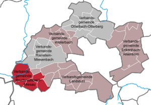
In Germany, especially in Rhineland-Palatinate, districts are divided into smaller groups of towns and villages. These groups are called Verbandsgemeinden. Think of them as mini-districts within the main district. Each Verbandsgemeinde has its own main town. This town is often where the local offices are located.
Towns and Villages in the District
The Kaiserslautern district has several Verbandsgemeinden. Each of these groups contains many smaller towns and villages. Some of these places are also considered "towns" themselves, which means they are bigger and have more services.
| Verbandsgemeinden | |||
|---|---|---|---|
|
|
|
|
| 1seat of the Verbandsgemeinde; 2town | |||
See also
 In Spanish: Distrito de Kaiserslautern para niños
 | Janet Taylor Pickett |
 | Synthia Saint James |
 | Howardena Pindell |
 | Faith Ringgold |


