Kameyama, Mie facts for kids
Quick facts for kids
Kameyama
亀山市
|
|||||||||||
|---|---|---|---|---|---|---|---|---|---|---|---|

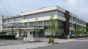
Kameyama City Hall
|
|||||||||||
|
|||||||||||

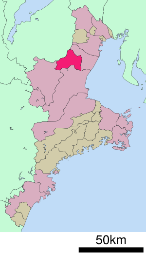
Location of Kameyama in Mie Prefecture
|
|||||||||||
| Country | Japan | ||||||||||
| Region | Kansai | ||||||||||
| Prefecture | Mie | ||||||||||
| Area | |||||||||||
| • Total | 190.91 km2 (73.71 sq mi) | ||||||||||
| Population
(August 2021)
|
|||||||||||
| • Total | 49,457 | ||||||||||
| • Density | 259.059/km2 (670.960/sq mi) | ||||||||||
| Time zone | UTC+9 (Japan Standard Time) | ||||||||||
| Phone number | 0595-82-1111 | ||||||||||
| Address | 577 Honmaru-cho, Kameyama-shi, Mie-ken 519-0195 | ||||||||||
| Climate | Cfa | ||||||||||
|
|||||||||||
Kameyama (亀山市 (Kameyama-shi)) is a city located in the northern part of Mie Prefecture, Japan. As of August 2021, about 49,457 people lived in Kameyama. The city covers an area of about 190.91 square kilometers (73.71 sq mi).
Contents
Geography of Kameyama
Kameyama is in the north-central part of Mie Prefecture. The Suzuka Mountains are to the northwest, and the Nunobiki Mountains are to the southwest. Forests cover more than half of the city's land.
Cities Near Kameyama
Kameyama shares borders with several other cities:
Kameyama's Climate
Kameyama has a Humid subtropical climate. This means it has warm summers and cool winters. There is usually little to no snowfall. The average temperature in Kameyama is about 15.1 degrees Celsius (59.2 °F). The city gets about 1853.7 millimeters (73 inches) of rain each year. September is usually the wettest month. Temperatures are highest in August, around 26.7 degrees Celsius (80.1 °F). They are lowest in January, around 4.3 degrees Celsius (39.7 °F).
| Climate data for Kameyama (1991−2020 normals, extremes 1979−present) | |||||||||||||
|---|---|---|---|---|---|---|---|---|---|---|---|---|---|
| Month | Jan | Feb | Mar | Apr | May | Jun | Jul | Aug | Sep | Oct | Nov | Dec | Year |
| Record high °C (°F) | 16.9 (62.4) |
21.2 (70.2) |
25.6 (78.1) |
29.9 (85.8) |
32.9 (91.2) |
35.4 (95.7) |
38.3 (100.9) |
37.9 (100.2) |
36.3 (97.3) |
32.7 (90.9) |
25.9 (78.6) |
21.5 (70.7) |
38.3 (100.9) |
| Mean daily maximum °C (°F) | 8.8 (47.8) |
9.6 (49.3) |
13.5 (56.3) |
19.1 (66.4) |
23.5 (74.3) |
26.3 (79.3) |
30.2 (86.4) |
31.7 (89.1) |
27.7 (81.9) |
22.3 (72.1) |
16.8 (62.2) |
11.3 (52.3) |
20.1 (68.1) |
| Daily mean °C (°F) | 4.3 (39.7) |
4.7 (40.5) |
8.0 (46.4) |
13.2 (55.8) |
18.0 (64.4) |
21.6 (70.9) |
25.6 (78.1) |
26.7 (80.1) |
23.0 (73.4) |
17.4 (63.3) |
11.7 (53.1) |
6.6 (43.9) |
15.1 (59.1) |
| Mean daily minimum °C (°F) | 0.1 (32.2) |
0.3 (32.5) |
3.0 (37.4) |
7.9 (46.2) |
12.9 (55.2) |
17.6 (63.7) |
22.1 (71.8) |
22.9 (73.2) |
19.2 (66.6) |
13.0 (55.4) |
6.8 (44.2) |
2.2 (36.0) |
10.7 (51.2) |
| Record low °C (°F) | −5.8 (21.6) |
−6.5 (20.3) |
−4.4 (24.1) |
−1.0 (30.2) |
3.7 (38.7) |
9.6 (49.3) |
14.0 (57.2) |
14.4 (57.9) |
8.1 (46.6) |
1.9 (35.4) |
−1.7 (28.9) |
−5.4 (22.3) |
−6.5 (20.3) |
| Average precipitation mm (inches) | 57.3 (2.26) |
68.8 (2.71) |
120.0 (4.72) |
153.4 (6.04) |
203.0 (7.99) |
255.8 (10.07) |
211.2 (8.31) |
180.8 (7.12) |
284.1 (11.19) |
178.8 (7.04) |
81.3 (3.20) |
59.3 (2.33) |
1,853.7 (72.98) |
| Average precipitation days (≥ 1.0 mm) | 8.1 | 8.7 | 10.9 | 10.1 | 10.7 | 12.6 | 12.1 | 10.3 | 12.1 | 10.0 | 6.8 | 7.5 | 119.9 |
| Mean monthly sunshine hours | 145.6 | 142.9 | 176.3 | 191.1 | 196.4 | 145.1 | 163.9 | 195.1 | 149.8 | 158.1 | 154.3 | 155.3 | 1,973.7 |
| Source: Japan Meteorological Agency | |||||||||||||
Kameyama's Population Changes
The number of people living in Kameyama has slowly grown over the last 50 years.
| Historical population | ||
|---|---|---|
| Year | Pop. | ±% |
| 1960 | 39,148 | — |
| 1970 | 37,817 | −3.4% |
| 1980 | 40,578 | +7.3% |
| 1990 | 45,045 | +11.0% |
| 2000 | 46,606 | +3.5% |
| 2010 | 51,047 | +9.5% |
History of Kameyama
Kameyama grew up around Kameyama Castle. This type of town is called a jōkamachi, or castle town. The castle belonged to the Ise-Kameyama Domain during the time of the Tokugawa shogunate.
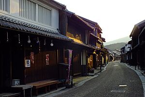
In the early 1600s, Kameyama was also an important post station called Kameyama-juku. Post stations were places where travelers could rest along the Tōkaidō road. This road connected Edo (now Tokyo) with Kyoto. Two other important post stations, Seki-juku and Sakashita-juku, are also within Kameyama's current borders.
In 1954, Kameyama officially became a city. Later, in 2005, the town of Seki joined with Kameyama.
Economy in Kameyama
One of the traditional products of Kameyama is Candles. Today, Kameyama is also home to a very large factory that makes LCD screens. This factory is run by Sharp Corporation and started operating in 2004.
Education in Kameyama
Kameyama has many schools for young people. The city government runs eleven public elementary schools and three public middle schools. There is also one public high school, managed by Mie Prefecture. In addition, Kameyama has one private high school.
Transportation in Kameyama
Kameyama is a hub for both trains and highways.
Railway Lines
You can travel by train through Kameyama on these lines:
 JR Tōkai – Kansai Main Line
- Idagawa - Kameyama
 JR Tōkai – Kisei Main Line
- Kameyama - Shimonoshō
 JR West – Kansai Main Line
- Kameyama - Seki - Kabuto
Highways
Major expressways and national routes pass through Kameyama:
 Higashi-Meihan Expressway
 Ise Expressway
 Shin-Meishin Expressway
 National Route 1
 National Route 25
 National Route 306
Fun Places to Visit
- Kameyama Castle - Explore the history of the castle town.
- Seki-juku - Walk through a well-preserved historic post station.
Sister Cities
Kameyama has special friendships with other cities, called "sister cities":
Famous People from Kameyama
- Shiro Hattori - a well-known linguist (someone who studies languages)
- Teinosuke Kinugasa - a famous film director
- Kiyoshi Toyoda - a professional baseball player
See also
 In Spanish: Kameyama (Mie) para niños


