Kandal province facts for kids
Quick facts for kids
Kandal
កណ្ដាល
|
||
|---|---|---|

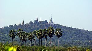
Oudong, the 17th century capital of Cambodia, is located in Kandal province
|
||
|
||

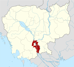
Map of Cambodia highlighting Kandal province
|
||
| Country | ||
| Provincial status | 1907 | |
| Capital | Ta Khmau | |
| Subdivisions | 10 districts; 1 municipality | |
| Area | ||
| • Total | 3,179 km2 (1,227 sq mi) | |
| Area rank | 19th | |
| Elevation | 10 m (30 ft) | |
| Population
(2019)
|
||
| • Total | ||
| • Rank | 2nd | |
| • Density | 378/km2 (980/sq mi) | |
| • Density rank | 2nd | |
| Time zone | UTC+07:00 (ICT) | |
| ISO 3166 code | KH-8 | |
| HDI (2017) | 0.591 medium |
|
Kandal (which means "Middle" in Khmer) is a province in Cambodia. It is located in the southeastern part of the country. Kandal completely surrounds Phnom Penh, which is the capital city of Cambodia.
The province shares borders with several other Cambodian provinces. These include Kampong Speu and Takéo to the west. To the north, it borders Kampong Chhnang and Kampong Cham. Prey Veng is to the east. Kandal also has an international border with Vietnam to the south.
Kandal is the second most populated province in Cambodia. Only the capital city, Phnom Penh, has more people. The capital and largest city of Kandal province is Ta Khmau. This city is about 8 kilometers (5 miles) south of central Phnom Penh. Kandal is known as one of the richer provinces in Cambodia.
Contents
Geography of Kandal
Land and Rivers
Kandal province completely surrounds the capital city of Phnom Penh. It is part of the larger area around Phnom Penh, where over a million people live. When you travel from Phnom Penh, it's hard to tell where one province ends and Kandal begins.
The land in Kandal is mostly flat and wet. It has many rice fields and other farms. The province is generally low, with an average height of only 10 meters (about 33 feet) above sea level. Two of Cambodia's largest rivers flow through Kandal: the Bassac and Mekong Rivers.
Kandal's Climate
Kandal province has a warm and humid tropical climate. The rainy season, also called the monsoon season, usually starts in May and lasts until October. The rest of the year is the dry season. The hottest time of year is from March to May. The coolest period is from November to March.
Economy and Industries
Kandal province is very important for the economy of Phnom Penh. Farming and fishing are the two main ways people make a living here. Important farm products include palm oil, peanuts, rice, and pepper.
Besides farming and fishing, Kandal also has many small home-based businesses. These "cottage industries" create beautiful items. People in Kandal are skilled at wood carving, making silk products, and other handicrafts. Many large clothing factories are also located in Kandal province. These factories employ over 500,000 workers.
Administrative Divisions
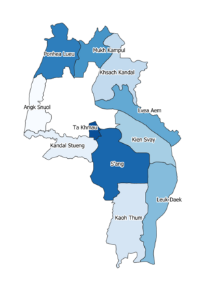
Kandal province is divided into 10 districts and 2 municipalities. These districts are further split into 146 communes. Communes are then divided into 1087 villages.
| ISO code | Name | Khmer |
|---|---|---|
| 08-01 | Kandal Stueng | កណ្ដាលស្ទឹង |
| 08-02 | Kien Svay | កៀនស្វាយ |
| 08-03 | Khsach Kandal | ខ្សាច់កណ្ដាល |
| 08-04 | Kaoh Thum | កោះធំ |
| 08-05 | Leuk Daek | លើកដែក |
| 08-06 | Lvea Aem | ល្វាឯម |
| 08-07 | Mukh Kampul | មុខកំពូល |
| 08-08 | Angk Snuol | អង្គស្នួល |
| 08-09 | Ponhea Lueu | ពញាឮ |
| 08-10 | S'ang | ស្អាង |
| 08-11 | Ta Khmau | តាខ្មៅ |
| 08-12 | Arey Ksat | អរិយក្សត្រ |
Two districts, Khsach Kandal and Lvea Aem, are located on the east side of the Mekong River.
See also
 In Spanish: Provincia de Kandal para niños
 | Victor J. Glover |
 | Yvonne Cagle |
 | Jeanette Epps |
 | Bernard A. Harris Jr. |


