
Karaikudi facts for kids
Quick facts for kids
Karaikudi
Capital of Chettinad
|
|
|---|---|
|
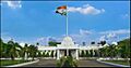
Alagappa University
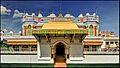
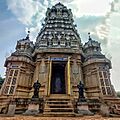
Kunnakudi Murugan Temple
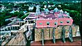
Kanadukathan Palace
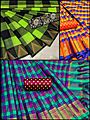
Kandangi
Vallal Dr. Alagappar Museum
Tamil Thaai Temple
Karaikudi Junction
|
|
| Nickname(s):
Chettinad, Heritage City, Food City, City of Education.
|
|

Karaikudi
Location in Tamil Nadu
|
|
| Country | India |
| State | Tamil Nadu |
| District | Sivaganga |
| Region | Chettinad |
| Government | |
| • Type | City Corporation |
| • Body | Karaikudi City Municipal Corporation |
| Area | |
| • Total | 94.31 km2 (36.41 sq mi) |
| Area rank | 20th |
| Elevation | 118 m (387 ft) |
| Population
(2023)
|
|
| • Total | 303,291 |
| • Rank | 30th |
| • Density | 3,215.89/km2 (8,329.1/sq mi) |
| Languages | |
| • Official | Tamil English |
| Time zone | UTC+5:30 (IST) |
| PIN |
630001 630002 630003 630004 630005 630006
|
| STD code | 04565 |
| Vehicle registration | TN-63Z |


Karaikudi is a big city in the Sivaganga district of Tamil Nadu, India. It's also one of the largest urban areas in Tamil Nadu. Karaikudi is part of a region called Chettinad. It's known for its huge, beautiful houses made from a special type of limestone, called Kaarai veedu. Because of these houses, it's now a City Municipal Corporation. Locally, people sometimes call it Kaarai Nagar. The city corporation covers about 94 square kilometers and is growing with new government projects.
People in Karaikudi vote for their leaders. They elect a member to the Tamil Nadu Legislative Assembly every five years. They also elect a Member of Parliament (MP) for the Sivaganga Lok Sabha constituency every five years. The city is managed by the Karaikudi Municipal Corporation. In 2023, the city had a population of over 300,000 people. This area includes Karaikudi City Corporation and nearby towns and villages.

This city is famous for Karaikudi Kandangi sarees. These are special sarees woven in this area. The Indian government has given these sarees a special "geographical indication" tag. This means they are unique to this region.
The delicious Chettinad cuisine also started in the areas around Karaikudi.
Karaikudi is one of the cities chosen for the AMRUT Schemes by the central government. This means the government of Tamil Nadu is working on many development projects here.
Contents
History of Karaikudi

The city's name comes from a thorny plant called Karai. In old writings, it was called Karaikudi. The town was founded in the 1800s. The oldest building known is the Koppudaiya Nayagi Amman Temple.
Famous leaders also visited Karaikudi. Mahatma Gandhi gave two speeches here in 1927. The poet Bharathiyar visited in 1919 for an event. After India became independent, the city grew a lot in industries.
Karaikudi and the surrounding areas are known as "Chettinad". This region has 73 villages and 2 towns. It covers about 1,550 square kilometers in the Sivagangai and Pudukottai districts of Tamil Nadu. Karaikudi is the biggest town in Sivaganga district.
Chettinad is very popular for its unique palaces and buildings. These buildings show the special Chettinad architecture. Other places to visit include Kannadasan Manimandapam and Kamban Manimandapam. The Thousand Windows House is also a popular spot.
The first Temple for Mother Tamil, called Tamil Thai Kovil, is in Karaikudi. It was built in 1993.
People and Population
In 2023, the population of Karaikudi was about 303,291 people. According to the 2011 census, Karaikudi had 181,125 people. There were 1,000 females for every 1,000 males, which is higher than the national average.
About 19,619 children were under six years old. The city's average literacy rate was 81.48%. This is higher than the national average of 72.99%. Most people in Karaikudi are Hindus, making up 83.9% of the population. Muslims are 11.39%, and Christians are 4.3%.
Geography and Climate
 |
ponnamaravathi | pudukottai | aranthangi | |
| Tirupattur | Avudaiyarkoil | |||
| kalaiyarkoil | devakottai | Thondi |
Karaikudi is in the Sivagangai district of Tamil Nadu. The Trichy–Rameswaram Highway goes through the city. The Thennar River flows through South Karaikudi.
Karaikudi is located at 10.07°N and 78.78°E. It is about 82 meters above sea level. The land in Karaikudi is mostly flat. There are some rocky areas around the town, especially to the west.
The soil is a hard red type and not good for farming. The water level underground is usually 3 to 6 feet deep. It rises to about 1 meter during rainy seasons. Since the 1970s, Karaikudi gets its water from deeper underground sources.
The average highest temperature is about 34°C. The average lowest temperature is about 24°C. Karaikudi gets about 920 mm of rain each year.
Culture and Landmarks

Karaikudi is known for its rich culture and many landmarks.
Famous Temples
There are several important temples in and around the city:
- Karaikudi Nagara Sivan Kovil: This temple is in the city center. It was built by the Nagarathars/Chettiars in the Dravidian style.
- Koppudaiya Amman Kovil: Located in Kallukatti, this is another important temple in Karaikudi.
- Ariyakudi Thiruvenkatamudayan Temple: This is one of the biggest Vishnu temples in the Chettinad region. It is about 2 km away.
- Pillayarpatti Karpagavinayagar temple: This temple is about 12 km away.
- Kundrakudi Shanmughanathar Temple: Located about 9 km from Karaikudi.
- Mathur Ainootreeswarar Temple: About 6 km from Karaikudi.
- Kandanur Kandaneswarar Sivan Temple: About 8.5 km away.
- Koviloor Kotravaaleeswarar Sivan Temple: About 6 km away.
Other Attractions
- Thirumayam fort: This historical fort is about 20 km from the city.
- Kanadukathan palace and Athangudi palace: These are grand palaces showing Chettinad architecture.
- Kannadasan manimandapam and Kamban manimandapam: These are memorials for famous Tamil writers.
- Azhagappar museum: A museum with interesting collections.
- Sankarapathi Fort: Located in Amaravathiputhur.
Festivals and Sports
- Siraavayal Manjuvirattu: This is a type of Jallikattu (bull-taming sport). It happens every year during the Pongal festival in January. Bulls from different parts of Tamil Nadu take part.
Economy and Industry
Karaikudi is a growing city in the Sivaganga district. UNESCO has offered to create a Chettinad Heritage Museum here. This is because the region has a unique architectural style.
Tourism is becoming very important. Many tourists, both from India and other countries, visit all year. The government has recognized Karaikudi as a heritage town. It is also considered a potential World Heritage Site.
Local Products
- Chettinad Kottan: These are palm leaf baskets woven by women in the region. They are known for their unique style and colors. Chettinad Kottan received a Geographical Indication tag in 2013.
- Chettinadu Kandangi sarees: These are popular sarees made in the area.
- Athangudi tiles: These are special cement tiles, like mosaics. They are used in the grand houses and are now a source for handicraft businesses.
Other Industries
Around 250 rice mills and paper mills are located in Puduvayal and Pallathur. These are suburban areas of Karaikudi. This makes the region an important trade and commercial area. It is sometimes called the "second rice bowl of Tamil Nadu".
Indian Overseas Bank was founded in Karaikudi on February 10, 1937. It was started by M. Ct. M. Chidambaram Chettyar.
Major Organizations
Karaikudi is home to several important government and research organizations.
- C.E.C.R.I (Central Electrochemical Research Institute): This institute is part of CSIR. It works on new and better products and processes in electrochemical technologies. It started on July 25, 1948. It also has research centers in Thondi and Mandapam.
- TNSTC: The Tamil Nadu State Transport Corporation has its regional office here. It provides bus services for Sivaganga and Ramanathapuram Districts. It has been operating since April 1, 1983.
- BSNL: Bharat Sanchar Nigam Limited has its regional headquarters in Karaikudi. It provides phone services for the Karaikudi Telecom District. This district includes Sivaganga and Ramanathapuram.
- AAVIN Karaikudi Dairy: This dairy supplies milk and milk products to many southern districts. It collects milk from Sivaganga and Ramanathapuram Districts. It has been operating since 1983.
- Postal Sorting Office: Karaikudi has a main postal sorting office. It handles all mail for Sivaganga and Ramanathapuram districts. It also serves as a postal hub for these districts.
Transportation
Karaikudi has good connections by road and rail.
By Air
The closest airports are Tiruchirapalli International Airport (95 km away) and Madurai Airport (100 km away).
Karaikudi also has an old airstrip called Chettinad Airport. It was used during World War II. The Indian government plans to reopen this airfield under the UDAN scheme.
By Rail
Karaikudi Junction railway station is a main train station for the city and nearby areas. You can find a full list of stations around Karaikudi in Suburban Stations.
By Road
The city has two bus terminals. The "Rajaji Bus-stand" (also called the Old Bus Terminal) serves buses connecting Karaikudi to nearby villages and smaller towns. The new bus terminal (Karaikudi Bus Terminal) handles longer-distance buses. These buses go to cities like Chennai, Bangalore, Coimbatore, Madurai, and Trichy.
Education
Karaikudi is an important center for education in Sivaganga district. As of 2011, there were many government and private schools. The city also has several colleges.
Alagappa University is located here. Alagappa Chettiar College of Engineering and Technology is the oldest college, started in 1953. Other colleges include Alagappa Government Arts College and Alagappa Polytechnic College.
Many schools and colleges in Karaikudi received help from a businessman and kind person named Alagappa Chettiar. He himself went to Sri Meenakshi Sundareswarar Vidyalaya. This school, on Sivan Koil Street, dates back to 1913. It is now SMSV Higher Secondary School for Boys. You can find more educational places in List of educational institutions in Karaikudi.
Utility Services
Electricity and Water
The Tamil Nadu Electricity Board (TNEB) manages electricity supply in Karaikudi. The city and its suburbs are part of the Sivaganga Electricity Distribution Circle.
Karaikudi Municipality provides water from seven borewells located at Sambai Oothu. This is an artesian aquifer, which means water flows naturally from it.
Waste Management and Drainage
In 2011, about 45 metric tonnes of solid waste were collected daily. The city is working on an underground drainage system. For now, wastewater is handled through septic tanks, open drains, and public toilets. The municipality maintained about 46.55 km of storm water drains in 2011.
Healthcare and Markets
As of 2011, there was one government hospital and 13 private hospitals in the city. The municipality runs one daily market called Anna Daily Market. There are also three weekly markets (Uzhavar Santhai). These markets serve the needs of the city and nearby rural areas.
Images for kids
-
Alagappa University
-
Kunnakudi Murugan Temple
-
Kanadukathan Palace
-
Kandangi
-
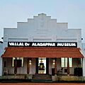
Vallal Dr. Alagappar Museum
-
Tamil Thaai Temple
-
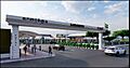
Karaikudi Junction
See also
 In Spanish: Karaikkudi para niños
