
Karekare, New Zealand facts for kids
Quick facts for kids
Karekare
|
|
|---|---|

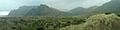
Waves rippling over Karekare Beach
|
|
| Country | New Zealand |
| Region | Auckland Region |
| Ward | Waitākere ward |
| Community board | Waitākere Ranges Local Board |
| Electorates |
|
| Area | |
| • Total | 11.92 km2 (4.60 sq mi) |
| Population
(June 2023)
|
|
| • Total | 320 |
| • Density | 26.8/km2 (69.5/sq mi) |
Karekare is a small town on the coast in West Auckland, New Zealand. It sits between the Waitākere Ranges and a big black sand surf beach.
Contents
Exploring Karekare's Geography
Karekare is about 35 kilometers (22 miles) west of Auckland city. It is south of the larger beach of Piha and north of Whatipu. To its east is the Centennial Memorial Park, which covers most of the native bushland in the Waitākere Ranges.
Two streams, Company Stream (also called Waiteahoaho) and Karekare Stream, meet at Karekare Beach. You can find the beautiful Karekare Falls a bit further inland from the beach.
The beach is divided into two parts by the Karekare Stream. The southern part is Karekare Beach, and the northern part is Tāhoro / Union Bay. Two important natural landmarks are The Watchman (also called Te Matua), a large hill on the beach, and Paratahi Island, which is south of Karekare.
Karekare is actually what's left of an ancient volcano! This volcano, called the Waitākere Volcano, was pushed up by Earth's forces millions of years ago. The Watchman (Te Matua) is the hardest part of the old volcano's crater. Paratahi Island is also part of the volcano, formed from cooled lava.
Karekare's Rich History
The Te Kawerau ā Maki people traditionally lived in Karekare and the wider Waitākere Ranges area. Karekare is special because some old fabrics made before Europeans arrived have been found here. The ocean between Piha and the Pararaha Valley was known as Waikarekare, meaning "turbulent waters." Over time, this name became Kakare and then Karekare, used for the beach and the whole area.
Legends of Karekare
A traditional Te Kawerau ā Maki story tells about three rocks on the beach. The legend says that Te Matua (The Watchman), the big headland, had two children. These children could walk during a time called Te Ao Kohatu, when even rocks could move. Te Matua's children played on the beach, but one child wandered too far.
When Te Ao Kohatu ended, the children were frozen in place. Te Tokapiri, the child who stayed close to their mother, remained nearby. Te Tokapaoke, the disobedient child, stands alone in the ocean at the southern end of Karekare. Te Tokapaoke became known as Paratahi Island.
Early Māori Settlement
Karekare was an important settlement for Te Kawerau ā Maki in the Waitākere Ranges. They were known for growing a lot of kūmara (sweet potato) inland. In the mid-1700s, a Te Kawerau ā Maki leader named Kowhatu-ki-te-uru, who was skilled at building stone forts (called pā), settled at Karekare.
He built a pā called Te Kaka Whakaara ("The Kākā Parrot Standing Watch") on The Watchman (Te Matua). The village near the pā was called Te Marae o Mana, named after Kowhatu-ki-te-uru's son. Their farms were known as Māraroa ("The Great Gardens"). Other important pā in the area were on Te Ahua Point and at Te Aoaho (above Karekare Falls).
Musket Wars and Aftermath
In 1826, during the Musket Wars, the Te Kaka Whakaara pā was attacked by two Ngāpuhi war parties (called taua). The Te Kawerau ā Maki people fought back by throwing rocks, but they couldn't stand against the muskets. Many Te Kawerau ā Maki people were lost, especially at Wharengarahi, a cave where women, children, and elders were hiding. Because of this battle, Karekare was left empty for a while after the war, due to the tapu (sacred restriction) from the deaths.
European Settlement and Industry
In the early days of European settlement, Karekare had two Kauri timber mills. The Karekau Sawmill operated from 1881 to 1886, and a smaller mill opened in 1906. In the early 1900s, the lower Karekare valley was farmland, looked after by the Farley family. In 1935, the Karekare Surf Club was started to help keep swimmers safe.
Karekare Today
Today, artists like Sir Peter Siddell and Joyce Campbell have lived in Karekare, finding inspiration in its beautiful landscape. Karekare is also home to the Karekare House Artists Residency. This program allows artists to live in the historic Karekare House and create art for three months each year.
In February 2023, Cyclone Gabrielle caused a lot of damage in the area. Many historic homes were harmed or destroyed.
Karekare's Population
Statistics New Zealand describes Karekare as a rural settlement. It covers about 11.92 square kilometers (4.60 sq mi). As of 2023, about 309 people live there.
The population of Karekare has grown over the years:
- 2006: 192 people
- 2013: 243 people
- 2018: 297 people
- 2023: 309 people
In the 2023 census, there were slightly more males than females. The average age was 41.4 years. About 21.4% of the people were under 15 years old. Most people (92.2%) identified as European, with 12.6% identifying as Māori. English is spoken by most residents. About 23.3% of people were born outside New Zealand.
Most people in Karekare reported having no religion (77.7%). Many adults had a bachelor's degree or higher. The average income was $37,900. About 44.4% of people aged 15 and older worked full-time.
Visiting Karekare
In the past, holidaymakers would travel by coach from Glen Eden to stay at the Karekare guest house. Today, Karekare is still a popular place for people from Auckland to visit in summer. It gets fewer visitors than nearby Piha, partly because the road is narrow. There are surf patrols during summer to help keep swimmers safe.

You can take a short walk from the road to reach the base of the Karekare Falls. However, the path to the top of the falls is now closed. This is to help stop the spread of Kauri dieback disease, which harms Kauri trees.
.png)
Karekare has been featured in popular culture. The band Crowded House recorded much of their 1993 album Together Alone here. The well-known Dub/Reggae group, Salmonella Dub, also used the name for their album Feel the Seasons Change - Live with the NZSO. The beautiful beach scenes in the famous film The Piano were also shot at Karekare and Piha.
Staying Safe at Karekare Beach
The ocean currents (rips) along this coast are very strong and can change quickly. They have caused several drownings. Lifeguards advise everyone to swim only between the red and yellow flags, and only when lifeguards are on duty.
Education in Karekare
Karekare has a small primary school called Lone Kauri School, with about 30 students. It operates as a branch of Oratia School and is overseen by a senior teacher.
Images for kids
-
Looking north from the southern end of Karekare Beach.
