Kareli Municipality facts for kids
Quick facts for kids
Kareli Municipality
ქარელის მუნიციპალიტეტი
|
|||
|---|---|---|---|
|
Municipality
|
|||
|
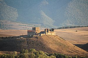
Mdzovreti fortress
|
|||
|
|||

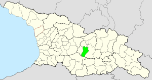
Location of Kareli Municipality in Georgia
|
|||
| Country | |||
| Region | Shida Kartli | ||
| Capital | Kareli | ||
| various | 1 town, 1 townlet, and 73 villages | ||
| Area | |||
| • Total | 687.9 km2 (265.6 sq mi) | ||
| Population
(2014)
|
|||
| • Total | 41,316 | ||
| • Density | 60.061/km2 (155.557/sq mi) | ||
| Time zone | UTC+4 | ||
| Website | Official site of shida kartli region: http://www.shidakartli.gov.ge/index.php?cat=77&par=6 | ||
Kareli (Georgian: ქარელის მუნიციპალიტეტი) is a district in the country of Georgia. It is part of the Shida Kartli region. Kareli is located in the central part of Georgia. It sits on the Shida Kartli plain. To the east, it borders Gori. To the west, it borders Khashuri. To the south, it borders Borjomi. The total area of Kareli Municipality is about 688 square kilometers. Around 41,316 people live here. In Kareli, there are 35 public schools and one private school. There is also a library, a cultural center, and a museum.
Contents
Kareli's Past: A Look at Its History
Kareli has a long and interesting history. It is first mentioned in old writings from the Early Bronze Age. This shows that people lived here a very long time ago. By the 16th and 17th centuries, Kareli was already a busy city center. Much of the area was once part of the Tsitsishvili noble family's lands. This family was important for military, building, and cultural activities. Kareli is famous for many historical events. One important event was the Ecclesiastical Council of Ruisi-Urbnisi in 1103. Another was the Battle of Aradeti in 1483.
Until 1917, the land that is now Kareli Municipality was part of Gori Mazra. This was a division of Tbilisi Province. In 1930, it became part of Gori and Khashuri districts. Then, in 1939, it became its own separate district. For a short time in 1963-1964, it rejoined those districts. But since 1965, Kareli has been a separate district with its current borders.
Kareli's Economy: How People Make a Living
The economy in Kareli Municipality focuses on two main areas. These are processing industries and agriculture. There is a sugar factory in Kareli. Other food processing businesses also operate here. Agriculture is very important. Farmers grow fruits, vegetables, and grapes. They also raise animals. Major roads and railways pass through Kareli. This helps transport goods and connect the area to other parts of Georgia.
Population and Communities in Kareli
Kareli Municipality has one main town, which is its center. It also includes 82 villages. These villages are grouped into 18 administrative units. The main town and administrative center is Kareli. The other administrative units include:
- Urbnisi
- Ruisi
- Agara
- Bebnisi
- Kekhijvari
- Khvedureti
- Akhalsopeli
- Mokhisi
- Dvani
- Zghuderi
- Bredza
- Ftsa
- Dirbi
- Breti
- Abisi
- Avlev
- Giganti
Exploring Kareli's Historic Places
Kareli is home to many important historical buildings and cultural sites. These include:
- Mdzovreti Castle-Hall Complex
- Samtsevrisi church
- Kintsvisi Monastery
- Samtsevrisi Castle
- Kozifa Monastery
- Orkhevi Monastery
- Ortubani Monastery
- Dzadzvi Monastery
- The historic villages of Ruisi and Urbnisi.
Kareli also has beautiful natural spots. One is Bateti Lake, which is 1313 meters above sea level. In the Khvedurula river gorge, you can find a "red stone" waterfall. There are also Trekhvi boilers, where an old stone cross was discovered.
See also
 In Spanish: Municipio de Kareli para niños
 | William L. Dawson |
 | W. E. B. Du Bois |
 | Harry Belafonte |


