Kataskomiq facts for kids
Quick facts for kids
Kataskomiq
Whitworth
|
|
|---|---|

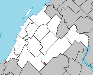
Location within Rivière-du-Loup RCM.
|
|
| Country | Canada |
| Province | Quebec |
| Region | Bas-Saint-Laurent |
| RCM | None |
| Constituted | unspecified |
| Area | |
| • Total | 1.60 km2 (0.62 sq mi) |
| Time zone | UTC−05:00 (EST) |
| • Summer (DST) | UTC−04:00 (EDT) |
Kataskomiq is a special area of land in Quebec, Canada. It is known as an Indian reserve, which is land set aside for the use of First Nations people. This reserve belongs to the Wolastoqiyik Wahsipekuk (Viger) First Nation, who are part of the Maliseet people.
Kataskomiq is located in the Bas-Saint-Laurent region of Quebec. While it is surrounded by the Rivière-du-Loup Regional County Municipality, it is not officially part of it. Before 2021, this reserve was known as Whitworth.
About Kataskomiq
Kataskomiq is listed in the Canadian Geographical Names Database. This database keeps track of names and locations across Canada. However, it is not listed by Indigenous and Northern Affairs Canada, which is a government department that works with Indigenous peoples.
Population Information
The population of Kataskomiq was recorded as 0 in the 2006 Canadian census. A census is like a big count of all the people living in a country. Kataskomiq did not appear in the later Canadian censuses from 2011 or 2016. This means that no one was officially living there during those times.
See also
 | Calvin Brent |
 | Walter T. Bailey |
 | Martha Cassell Thompson |
 | Alberta Jeannette Cassell |


