Kemblawarra, New South Wales facts for kids
Quick facts for kids KemblawarraWollongong, New South Wales |
|||||||||||||||
|---|---|---|---|---|---|---|---|---|---|---|---|---|---|---|---|

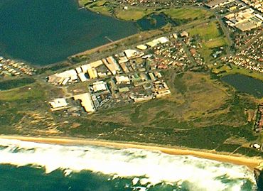
Aerial view from east
|
|||||||||||||||
| Postcode(s) | 2505 | ||||||||||||||
| Elevation | 8 m (26 ft) | ||||||||||||||
| Location |
|
||||||||||||||
| LGA(s) | City of Wollongong | ||||||||||||||
| State electorate(s) | Wollongong | ||||||||||||||
| Federal Division(s) | Whitlam | ||||||||||||||
|
|||||||||||||||
Kemblawarra is a suburb located in Wollongong, a city in New South Wales, Australia. It is known as an urban place, meaning it's a developed area with homes, shops, and businesses. Kemblawarra is a mix of different types of areas. You'll find places where people live, shops, and also light industrial zones.
Exploring Kemblawarra
Kemblawarra is officially recognized as an urban area. This means it's a busy part of the city. It includes parts of two other suburbs. These are Warrawong and Port Kembla.
Where is Kemblawarra Located?
Kemblawarra is found in the south-eastern part of Warrawong. It is located south of a road called Northcliffe Drive. It also covers the southern part of Port Kembla. This section is south of Parkes Street. This unique setup means Kemblawarra connects different parts of the wider Wollongong area.
What Can You Find in Kemblawarra?
Kemblawarra is a diverse suburb. It has areas for people to live in. These are called residential areas. There are also commercial areas, which means places with shops and businesses. Lastly, it has light industrial areas. These are places where smaller factories or workshops operate. This mix makes Kemblawarra an important part of the local economy.
 | Georgia Louise Harris Brown |
 | Julian Abele |
 | Norma Merrick Sklarek |
 | William Sidney Pittman |


