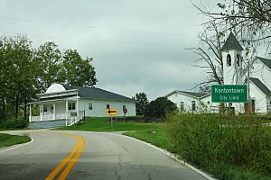
Kentontown, Kentucky facts for kids
Quick facts for kids
Kentontown
|
|
|---|---|
 |
|
| Country | United States |
| State | Kentucky |
| County | Robertson |
| Elevation | 725 ft (221 m) |
| Time zone | UTC-5 (Eastern (EST)) |
| • Summer (DST) | UTC-4 (EDT) |
| GNIS feature ID | 495664 |
Kentontown is a small place in Robertson County, Kentucky, in the United States. It's called an unincorporated community, which means it doesn't have its own local government like a city or town. Instead, it's part of the larger county.
Kentontown is located along two main roads: U.S. Route 62 and Kentucky Route 617. It lies southwest of Mount Olivet, which is the main town and county seat for Robertson County. A county seat is like the capital of a county, where the government offices are. Kentontown is about 725 feet (221 meters) above sea level.
History of Kentontown
Kentontown has been around for a long time. It was settled even before Robertson County was officially formed. This means people were living and building homes there before the county lines were drawn and its government was set up.
 | Victor J. Glover |
 | Yvonne Cagle |
 | Jeanette Epps |
 | Bernard A. Harris Jr. |


