Mount Olivet, Kentucky facts for kids
Quick facts for kids
Mount Olivet, Kentucky
|
|
|---|---|

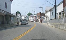
Downtown Mount Olivet
|
|

Location of Mount Olivet in Robertson County, Kentucky.
|
|
| Country | United States |
| State | Kentucky |
| County | Robertson |
| Incorporated | December 27, 1851 |
| Reincorporated | March 18, 1871 |
| Named for | the Mount of Olives |
| Area | |
| • Total | 0.83 sq mi (2.14 km2) |
| • Land | 0.83 sq mi (2.14 km2) |
| • Water | 0.00 sq mi (0.00 km2) |
| Elevation | 965 ft (294 m) |
| Population
(2020)
|
|
| • Total | 347 |
| • Density | 419.59/sq mi (162.08/km2) |
| Time zone | UTC-5 (Eastern (EST)) |
| • Summer (DST) | UTC-4 (EDT) |
| ZIP code |
41064
|
| Area code(s) | 606 |
| FIPS code | 21-53976 |
| GNIS feature ID | 2404322 |
Mount Olivet is a small city in Kentucky, United States. It is the main town and the "county seat" of Robertson County. This means it's where the county government offices are located. Mount Olivet is found where two roads, U.S. Route 62 and Kentucky Route 165, meet. In 2020, about 347 people lived there.
Contents
History of Mount Olivet
Long before Mount Olivet was a town, an important battle happened nearby. This was the Battle of Blue Licks in 1783. It was fought between American frontiersmen and Native American allies who supported the British. This battle was a big defeat for the Americans near the end of the American Revolutionary War.
Mount Olivet was started in 1820. It officially became a town on December 27, 1851. When Robertson County was created in 1867, Mount Olivet became its county seat. This made it the center for the county's government.
The town was later dissolved, but it was re-established on March 18, 1871. This happened because the Kentucky General Assembly, which is Kentucky's state legislature, passed a law. Until 2015, Mount Olivet was a "fifth-class city." Then, it was changed to a "home rule–class city." This means it has more power to make its own local laws.
In 1871, the town's border was set as a perfect circle. This circle was centered at the crossing of Main and Walnut streets. In 1981, the city clarified that this circle has a radius of about 2,620 feet (799 meters). In 2014, the city added about 26.38 acres (10.68 hectares) of land. This new land included the new Robertson County School and the roads leading to it.
Geography of Mount Olivet
Mount Olivet is located in Robertson County, Kentucky. The United States Census Bureau reports that the city covers a total area of about 0.4 square miles (1.0 square kilometer). All of this area is land, with no water.
Population and People
| Historical population | |||
|---|---|---|---|
| Census | Pop. | %± | |
| 1870 | 254 | — | |
| 1880 | 317 | 24.8% | |
| 1890 | 327 | 3.2% | |
| 1900 | 352 | 7.6% | |
| 1910 | 321 | −8.8% | |
| 1920 | 340 | 5.9% | |
| 1930 | 419 | 23.2% | |
| 1940 | 573 | 36.8% | |
| 1950 | 455 | −20.6% | |
| 1960 | 386 | −15.2% | |
| 1970 | 442 | 14.5% | |
| 1980 | 346 | −21.7% | |
| 1990 | 384 | 11.0% | |
| 2000 | 289 | −24.7% | |
| 2010 | 299 | 3.5% | |
| 2020 | 347 | 16.1% | |
| U.S. Decennial Census | |||
The population of Mount Olivet changes over time. In 1870, there were 254 people. By 1940, the population grew to 573 people. In 2020, the city had 347 residents.
According to the census from 2000, there were 289 people living in Mount Olivet. These people lived in 130 households. About 28.5% of these households had children under 18 years old. The average household had 2.22 people.
The people in the city were of different ages. About 26.0% were under 18 years old. About 20.8% were 65 years or older. The average age in the city was 40 years old.
Education in Mount Olivet
Mount Olivet has a lending library for its residents. It is called the Robertson County Public Library. This library provides books and other resources for the community.
See also
 In Spanish: Mount Olivet (Kentucky) para niños
 | Dorothy Vaughan |
 | Charles Henry Turner |
 | Hildrus Poindexter |
 | Henry Cecil McBay |

