Kenvil, New Jersey facts for kids
Quick facts for kids
Kenvil, New Jersey
|
|
|---|---|

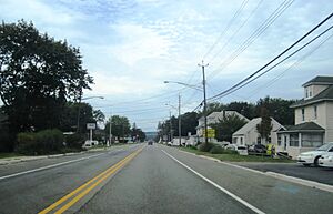
US 46 traveling through Kenvil
|
|

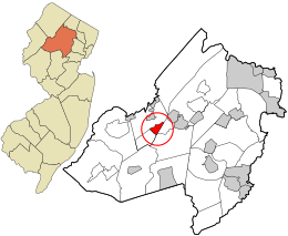
Location in Morris County and the state of New Jersey.
|
|
| Country | |
| State | |
| County | Morris |
| Township | Roxbury |
| Area | |
| • Total | 1.35 sq mi (3.51 km2) |
| • Land | 1.19 sq mi (3.07 km2) |
| • Water | 0.17 sq mi (0.43 km2) 15.89% |
| Elevation | 709 ft (216 m) |
| Population
(2020)
|
|
| • Total | 1,806 |
| • Density | 1,522.77/sq mi (587.92/km2) |
| Time zone | UTC−05:00 (Eastern (EST)) |
| • Summer (DST) | UTC−04:00 (Eastern (EDT)) |
| FIPS code | 34-36720 |
| GNIS feature ID | 02584005 |
Kenvil is a small community in Roxbury Township, Morris County, New Jersey. It's known as an "unincorporated community" and a "census-designated place" (CDP). This means it's a specific area that the government tracks for population and other data, even though it's not a separate town with its own local government.
In 2020, about 1,806 people lived in Kenvil. Before 2010, Kenvil was part of a larger area called Succasunna-Kenvil. But for the 2010 census, it became its own separate CDP.
Contents
Kenvil's Past
Kenvil was first called McCainsville. This was a long time ago, when the area was just starting to grow.
A very important part of Kenvil's history involves a factory. In 1872, the Atlantic Giant Powder Company opened the second dynamite plant in the United States right here. Later, in 1913, the Hercules Powder Company took over the plant. They also started making smokeless powder, which is used in things like fireworks and ammunition.
The plant had some serious accidents over the years. These incidents caused damage and sadness in the community. For example, there were unfortunate events in 1934, 1940, and 1989. The 1940 event was particularly impactful.
Where Kenvil Is
Kenvil covers a total area of about 1.58 square miles (4.09 square kilometers). Most of this area is land, about 1.33 square miles (3.44 square kilometers). The rest is water, which makes up about 0.25 square miles (0.65 square kilometers). This means that about 15.89% of Kenvil's area is water.
Who Lives in Kenvil
| Historical population | |||
|---|---|---|---|
| Census | Pop. | %± | |
| 2010 | 3,009 | — | |
| 2020 | 1,806 | −40.0% | |
| Population sources: 2010 2020 |
|||
Kenvil's Population in 2010
The 2010 United States census counted 3,009 people living in Kenvil. There were 1,095 households, which are groups of people living together. Out of these, 773 were families.
The population density was about 2,263 people for every square mile. Most of the people living in Kenvil were White (83.52%). There were also people who identified as Black or African American (2.19%), Asian (7.18%), and Native American (0.13%). Some people were from other races (4.55%) or from two or more races (2.43%). About 15.99% of the population identified as Hispanic or Latino.
Many households (30.3%) had children under 18 years old. More than half (54.6%) were married couples living together. About 10.4% of households had a female head of household with no husband. Around 25.0% of all households were made up of individuals living alone. About 13.1% of these individuals were 65 years old or older.
The average household had about 2.66 people. The average family had about 3.13 people.
The population's age range was spread out. About 20.9% were under 18. About 26.1% were between 25 and 44 years old. And 16.5% were 65 years or older. The average age in Kenvil was 42.2 years.
Getting Around Kenvil
Two important roads pass through Kenvil: U.S. Route 46 and Route 10. These roads help people travel to and from Kenvil.
There's also a railway line. The Dover and Rockaway River Railroad uses it to move goods by train. Trains usually run through the area a few times a week.
See also

- In Spanish: Kenvil para niños
 | Anna J. Cooper |
 | Mary McLeod Bethune |
 | Lillie Mae Bradford |


