Roxbury, New Jersey facts for kids
Quick facts for kids
Roxbury, New Jersey
|
||
|---|---|---|
|
Township
|
||

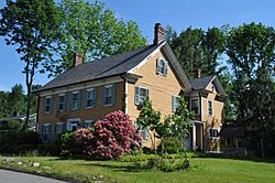
Cary Station, listed on the U.S. National Register of Historic Places
|
||
|
||

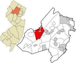
Location in Morris County and the state of New Jersey.
|
||

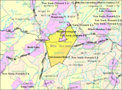
Census Bureau map of Roxbury Township, New Jersey
|
||
| Country | ||
| State | ||
| County | ||
| Established | December 24, 1740 | |
| Incorporated | February 21, 1798 | |
| Government | ||
| • Type | Faulkner Act (council–manager) | |
| • Body | Township Council | |
| Area | ||
| • Total | 21.98 sq mi (56.93 km2) | |
| • Land | 20.85 sq mi (54.01 km2) | |
| • Water | 1.13 sq mi (2.93 km2) 5.14% | |
| Area rank | 127th of 565 in state 7th of 39 in county |
|
| Elevation | 837 ft (255 m) | |
| Population
(2020)
|
||
| • Total | 22,950 | |
| • Estimate
(2023)
|
23,205 | |
| • Rank | 117th of 565 in state 6th of 39 in county |
|
| • Density | 1,100.6/sq mi (424.9/km2) | |
| • Density rank | 371st of 565 in state 27th of 39 in county |
|
| Time zone | UTC−05:00 (Eastern (EST)) | |
| • Summer (DST) | UTC−04:00 (Eastern (EDT)) | |
| ZIP Code | ||
| Area code(s) | 973 | |
| FIPS code | 3402764980 | |
| GNIS feature ID | 0882203 | |
Roxbury is a township located in southwestern Morris County, New Jersey. It's a place where many families live and grow. In 2020, about 22,950 people called Roxbury home. This township is about 36 miles (58 km) west of New York City. It's also 27 miles (43 km) west of Newark, New Jersey. Roxbury is a great community with a rich history.
Roxbury was first created on December 24, 1740. It was formed from parts of Morris Township. Later, on February 21, 1798, it officially became a township. This happened as part of New Jersey's first group of 104 townships. Over the years, some parts of Roxbury were used to form other towns. These include Mendham Township and Washington Township. Other towns formed from Roxbury were Chester Township and Jefferson Township. Also, Mount Olive Township, Mount Arlington, and Netcong were created.
Did you know that Tom's Diner in Roxbury was in a music video? It was featured in the video for the song Time After Time by Cyndi Lauper.
Contents
About Roxbury's Location and Land
Roxbury Township covers about 21.98 square miles (56.93 km2). Most of this area, 20.85 square miles (54.01 km2), is land. The rest, 1.13 square miles (2.93 km2), is water.
Several smaller communities are part of Roxbury. These include Kenvil, Landing, and Ledgewood. Other communities are Lower Berkshire Valley, Port Morris, and Succasunna. These are often called "unincorporated communities."
Other interesting places in Roxbury include Baker Mill Pond and Bertrand Island. You can also find Carys, Lake Junction, Lake Rogerene, Port Morris Landing, Rustic, and Shippenport here.
Roxbury shares its borders with many other towns. In Morris County, it borders Chester Township and Jefferson Township. It also borders Mine Hill Township, Mount Arlington, Mount Olive Township, Netcong, Randolph Township, and Wharton. In Sussex County, Roxbury borders Hopatcong and Stanhope.
Roxbury's Population Over Time
| Historical population | |||
|---|---|---|---|
| Census | Pop. | %± | |
| 1810 | 1,563 | * | — |
| 1820 | 1,792 | 14.7% | |
| 1830 | 2,262 | 26.2% | |
| 1840 | 2,231 | −1.4% | |
| 1850 | 2,269 | 1.7% | |
| 1860 | 2,865 | 26.3% | |
| 1870 | 3,320 | 15.9% | |
| 1880 | 2,139 | * | −35.6% |
| 1890 | 2,739 | 28.1% | |
| 1900 | 2,185 | * | −20.2% |
| 1910 | 2,414 | 10.5% | |
| 1920 | 2,976 | 23.3% | |
| 1930 | 3,879 | 30.3% | |
| 1940 | 4,455 | 14.8% | |
| 1950 | 5,707 | 28.1% | |
| 1960 | 9,983 | 74.9% | |
| 1970 | 15,754 | 57.8% | |
| 1980 | 18,878 | 19.8% | |
| 1990 | 20,429 | 8.2% | |
| 2000 | 23,883 | 16.9% | |
| 2010 | 23,324 | −2.3% | |
| 2020 | 22,950 | −1.6% | |
| 2023 (est.) | 23,205 | −0.5% | |
| Population sources: 1810–1920 1840 1850–1870 1850 1870 1880–1890 1890–1910 1910–1930 1940–2000 2000 2010 2020 * = Lost territory in previous decade. |
|||
Who Lives in Roxbury?
In 2020, Roxbury had a population of 22,950 people. Most residents, about 73.5%, were White. About 14.5% of the population was Hispanic or Latino. Asian residents made up about 5.6% of the population. Black or African American residents were about 2.8%. About 3% of people identified as being of mixed race.
In 2010, there were 23,324 people living in Roxbury. There were 8,292 households in the township. About 36% of these households had children under 18. Most households, 65.6%, were married couples. The average household had 2.80 people. The average family had 3.19 people.
About 24.6% of Roxbury's population was under 18 years old. About 12.6% were 65 or older. The median age in Roxbury was 41.9 years. This means half the people were younger and half were older than 41.9.
Shopping and Business in Roxbury
Roxbury is home to two large shopping centers. These are Ledgewood Mall and Roxbury Mall. Ledgewood Mall has a shopping area of 518,246 square feet. Roxbury Mall is even bigger, with 706,000 square feet of space. These malls offer many stores and services for residents.
Schools in Roxbury
The Roxbury School District serves students from kindergarten through twelfth grade. In the 2018–19 school year, the district had seven schools. About 3,551 students were enrolled. There were 328 teachers, meaning about 10.8 students per teacher.
The elementary schools are Franklin, Jefferson, Kennedy, and Nixon. They serve students in grades K–4. Lincoln / Roosevelt School teaches students in grades 5–6. Eisenhower Middle School is for grades 7–8. Finally, Roxbury High School serves students in grades 9–12.
Students from Mount Arlington also attend Roxbury High School. This is part of a special agreement between the school districts.
There is also a private school in Roxbury. St. Therese School is a Catholic school. It opened in 1963 and is part of the Roman Catholic Diocese of Paterson.
Getting Around Roxbury

Roads and Highways
As of 2010, Roxbury had 133.66 miles of roads. The township maintained most of these roads, about 107.03 miles. Morris County took care of 13.91 miles. The New Jersey Department of Transportation maintained 12.72 miles.
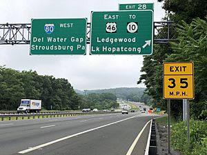
Several major roads pass through Roxbury. These include Interstate 80, U.S. Route 46, and U.S. Route 206. Also, Route 10 and Route 183 run through the township.
Public Transportation
The NJ Transit Lake Hopatcong station offers train service. You can take the Morris & Essex Lines or the Montclair-Boonton Line. These lines go to Hoboken Terminal or Pennsylvania Station in Midtown Manhattan. For Midtown Manhattan, you might need to transfer trains.
Freight trains also run through Roxbury on weekdays. These are the Morristown & Erie Railway's Chester Branch and High Bridge Branch lines.
Port Morris was once the start of the Lackawanna Cut-Off. This was an amazing railway project built between 1908 and 1911. NJ Transit is thinking about bringing back passenger train service on this route. It would connect the Pocono Mountains in Pennsylvania to Hoboken.
NJ Transit also has a local bus route, the 875. This bus travels between the Ledgewood Mall, Dover, and Morristown.
You can also find Lakeland Bus Lines stops in the Landing section of Roxbury. These buses provide service to and from the Port Authority Bus Terminal in Midtown Manhattan.
Famous People From Roxbury
Many interesting people have connections to Roxbury. Here are a few:
- Trevor Baptiste (born 1996) is a professional lacrosse player. He plays as a midfielder for the Boston Cannons.
- Dylan Castanheira (born 1995) is a soccer player. He plays as a goalkeeper for Fort Lauderdale CF.
- Harry "A" Chesler (1898–1981) was a pioneer in comic books. He helped create many comic features in the early days of comics.
- BettyLou DeCroce (born 1952) is a politician. She served in the New Jersey General Assembly.
- Philemon Dickerson (1788–1862) was a former Governor of New Jersey.
- Roberta Groner (born 1978) is an athlete. She competes in long-distance running events.
- Leo Warren Jenkins (1913–1989) was an educator. He was a president and chancellor of East Carolina University.
- Doug Miller (born 1969) is a soccer player and coach.
- Paige Monaghan (born 1996) is a professional soccer player. She plays for Sky Blue FC.
- Dave Moore (born 1969) was a football player. He played for the Buffalo Bills, Miami Dolphins, and Tampa Bay Buccaneers.
- Karen Ann Quinlan (1954–1985) was an important figure in the "right to die" discussion in the United States.
- Jetur R. Riggs (1809–1869) represented New Jersey in the U.S. House of Representatives.
- Tito Santana (born 1953) is a former professional wrestler.
See also
 In Spanish: Municipio de Roxbury para niños
 | Isaac Myers |
 | D. Hamilton Jackson |
 | A. Philip Randolph |


