
Stanhope, New Jersey facts for kids
Quick facts for kids
Stanhope, New Jersey
|
|
|---|---|
|
Borough
|
|

The Stanhope House
|
|

Map of Stanhope in Sussex County. Inset: Location of Sussex County highlighted in the State of New Jersey.
|
|

Census Bureau map of Stanhope, New Jersey
|
|

Stanhope, New Jersey
Location in Sussex County, New Jersey

Stanhope, New Jersey
Location in New Jersey

Stanhope, New Jersey
Location in the United States
|
|
| Country | |
| State | |
| County | Sussex |
| Incorporated | March 24, 1904 |
| Government | |
| • Type | Borough |
| • Body | Borough Council |
| Area | |
| • Total | 2.10 sq mi (5.43 km2) |
| • Land | 1.84 sq mi (4.76 km2) |
| • Water | 0.26 sq mi (0.67 km2) 12.25% |
| Area rank | 404th of 565 in state 20th of 24 in county |
| Elevation | 961 ft (293 m) |
| Population
(2020)
|
|
| • Total | 3,526 |
| • Estimate
(2023)
|
3,575 |
| • Rank | 429th of 565 in state 15th of 24 in county |
| • Density | 1,918.7/sq mi (740.8/km2) |
| • Density rank | 300th of 565 in state 4th of 24 in county |
| Time zone | UTC−05:00 (Eastern (EST)) |
| • Summer (DST) | UTC−04:00 (Eastern (EDT)) |
| ZIP Code |
07874
|
| Area code(s) | 973 |
| FIPS code | 3403770380 |
| GNIS feature ID | 0885408 |
Stanhope is a small town, also called a borough, located in Sussex County, New Jersey. In 2020, about 3,526 people lived here. This was a small decrease from the 3,610 people counted in 2010.
Stanhope officially became a borough on March 24, 1904. It was formed from parts of Byram Township.
Contents
Stanhope's Location and Land Area
Stanhope covers a total area of about 2.09 square miles (5.42 square kilometers). Most of this is land (1.84 square miles or 4.76 square kilometers). The rest is water (0.26 square miles or 0.66 square kilometers), making up about 12.25% of the total area.
Part of Lake Musconetcong is located within Stanhope. Stanhope is the southernmost town in Sussex County. It shares borders with several other towns. These include Byram Township and Hopatcong in Sussex County. It also borders Mount Olive Township, Netcong, and Roxbury in Morris County.
Who Lives in Stanhope?
| Historical population | |||
|---|---|---|---|
| Census | Pop. | %± | |
| 1910 | 1,031 | — | |
| 1920 | 1,031 | 0.0% | |
| 1930 | 1,089 | 5.6% | |
| 1940 | 1,100 | 1.0% | |
| 1950 | 1,351 | 22.8% | |
| 1960 | 1,814 | 34.3% | |
| 1970 | 3,040 | 67.6% | |
| 1980 | 3,638 | 19.7% | |
| 1990 | 3,393 | −6.7% | |
| 2000 | 3,584 | 5.6% | |
| 2010 | 3,610 | 0.7% | |
| 2020 | 3,526 | −2.3% | |
| 2023 (est.) | 3,575 | −1.0% | |
| Population sources: 1910–1920 1910 1910–1930 1940–2000 2000 2010 2020 |
|||
Stanhope's Population in 2010
In 2010, there were 3,610 people living in Stanhope. These people lived in 1,396 homes, and 958 of these were families. The town had about 1,966 people per square mile.
Most people in Stanhope were White (91.36%). Other groups included Black or African American (1.58%), Asian (2.33%), and Native American (0.08%). About 8.50% of the population was Hispanic or Latino.
About 22.7% of the people were under 18 years old. About 10.4% were 65 years or older. The average age in Stanhope was 39.5 years.
Schools in Stanhope
The Stanhope Public Schools educate students from kindergarten up to eighth grade. In the 2021-2022 school year, there was one school with 292 students and about 30 teachers. This means there were about 9.7 students for every teacher.
For high school, students from Stanhope attend Lenape Valley Regional High School. This high school serves students from Netcong and Byram Township, as well as Stanhope. In the 2021-2022 school year, the high school had 657 students and about 54 teachers. This means there were about 12.1 students per teacher. Stanhope has two seats on the high school's board of education.
Getting Around Stanhope
_at_the_exit_for_New_Jersey_State_Route_183_SOUTH_(Stanhope)_in_Stanhope,_Sussex_County,_New_Jersey.jpg)
As of 2010, Stanhope had about 16.76 miles of roads. The town itself took care of most of these roads (12.75 miles). The county maintained 2.24 miles, and the state maintained 1.77 miles.
Route 183 is the main road that goes through Stanhope. U.S. Route 206 also passes through the western part of town. This road connects to Interstate 80 in nearby Mount Olive.
When Interstate 80 was finished around 1974, the old U.S. Route 206 through Stanhope was renamed Route 183. Interstate 80 now helps traffic bypass Stanhope.
For public transportation, Lakeland Bus Lines offers bus service. These buses travel along Interstate 80 between Newton, New Jersey, and the Port Authority Bus Terminal in Midtown Manhattan, New York City.
Places to Visit in Stanhope
Since 1949, the Patriots' Path Council of the Boy Scouts of America has run two camps in Stanhope at the Mt. Allamuchy Scout Reservation.
- Camp Somers is a camp for Boy Scouts aged 12 to 17. They can stay overnight all year round.
- Camp Wheeler is a day camp for younger Cub Scouts.
The Plaster Mill was once part of an iron works. It was located along the Morris Canal, which ran through Stanhope. This mill was added to the National Register of Historic Places in 1977 because of its history.
Across the Musconetcong River in Netcong, you can find the Stanhope United Methodist Church. It is also known as the Church in the Glen. This church was added to the National Register of Historic Places in 2013 because of its special architecture.
Images for kids
-
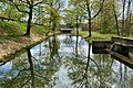
A section of the Morris Canal near Lock 1 West and Lake Musconetcong
-
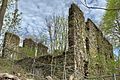
The ruins of the Plaster Mill
-
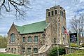
The Stanhope United Methodist Church


Famous People from Stanhope
- Gamaliel Bartlett (1796–1859): He was the first postmaster in Stanhope, starting in 1823. He might have also run an inn, possibly at the place now known as The Stanhope House.
- Rob Freeman (born 1981): A musician who was the guitarist and songwriter for the band Hidden in Plain View.
- Alicia Luciano (born 1983): She was crowned Miss New Jersey in 2002 and competed in the Miss America 2003 Pageant.
- Joe Reo: The lead singer for the band Hidden in Plain View.
- Dave Yovanovits (born 1981): A former football player who played as a guard for the Cleveland Browns.
See also
 In Spanish: Stanhope (Nueva Jersey) para niños
