
Netcong, New Jersey facts for kids
Quick facts for kids
Netcong, New Jersey
|
||
|---|---|---|
|
Borough
|
||

Stanhope United Methodist Church
The Church in the Glen |
||
|
||
| Motto(s):
All Roads Lead To Netcong
|
||

Location in Morris County and the state of New Jersey.
|
||

Census Bureau map of Netcong, New Jersey
|
||

Netcong, New Jersey
Location in Morris County, New Jersey

Netcong, New Jersey
Location in New Jersey

Netcong, New Jersey
Location in the United States
|
||
| Country | ||
| State | ||
| County | ||
| Incorporated | October 23, 1894 | |
| Named for | Musconetcong River | |
| Government | ||
| • Type | Borough | |
| • Body | Borough Council | |
| Area | ||
| • Total | 0.96 sq mi (2.48 km2) | |
| • Land | 0.83 sq mi (2.15 km2) | |
| • Water | 0.12 sq mi (0.32 km2) 13.33% | |
| Area rank | 509th of 565 in state 38th of 39 in county |
|
| Elevation | 906 ft (276 m) | |
| Population
(2020)
|
||
| • Total | 3,375 | |
| • Estimate
(2023)
|
3,665 | |
| • Rank | 432nd of 565 in state 37th of 39 in county |
|
| • Density | 4,053.1/sq mi (1,564.9/km2) | |
| • Density rank | 156th of 565 in state 4th of 39 in county |
|
| Time zone | UTC−05:00 (Eastern (EST)) | |
| • Summer (DST) | UTC−04:00 (Eastern (EDT)) | |
| ZIP Code |
07857
|
|
| Area code(s) | 973 | |
| FIPS code | 3402750130 | |
| GNIS feature ID | 0885316 | |

Netcong is a small town, called a borough, in southwestern Morris County, New Jersey. It is located on the shores of Lake Musconetcong.
In 2020, about 3,375 people lived there. This was a bit more than in 2010, when 3,232 people lived in Netcong.
The town was first known as South Stanhope. It was named Netcong in 1889 when a post office started using that name. Netcong officially became a borough on October 23, 1894. This happened after people voted for it. The land for the borough came from parts of Mount Olive Township and Roxbury Township.
Contents
History of Netcong
Netcong got its name from the Musconetcong River. The Lenape Native Americans named the river. Its name can mean "grass creek," "swamp stream," "rapid stream," or "clear stream place."
The river, along with the old Morris and Sussex Turnpike (built after 1801), helped the area grow. The Morris Canal, which opened in 1831, also made Netcong a good place for development.
After Netcong became a borough, its residents elected their first leaders. Abraham J. Drake was chosen as the first mayor on November 14, 1894. A count of the population in July 1895 showed 877 people living in Netcong.
Much of Netcong's business came from the Delaware, Lackawanna and Western Railroad. This railroad had its last stop in Morris County right in the heart of Netcong. The railroad also provided many jobs for the people living in the town.
In 1968, AT&T announced plans to build a special building in Netcong. It was a two-story building located 47 feet underground. This facility was designed to connect a major cable running between Boston and Miami. It was built to survive a nuclear attack and keep working for up to three weeks.
Netcong's Geography
Netcong covers about 0.96 square miles (2.49 square kilometers). Most of this area is land, about 0.83 square miles (2.16 square kilometers). The rest, about 0.13 square miles (0.33 square kilometers), is water.
Netcong shares its borders with a few other towns. These include Mount Olive Township and Roxbury Township in Morris County. It also borders Stanhope in Sussex County.
Netcong's Population Data
| Historical population | |||
|---|---|---|---|
| Census | Pop. | %± | |
| 1900 | 941 | — | |
| 1910 | 1,532 | 62.8% | |
| 1920 | 1,800 | 17.5% | |
| 1930 | 2,097 | 16.5% | |
| 1940 | 2,157 | 2.9% | |
| 1950 | 2,284 | 5.9% | |
| 1960 | 2,765 | 21.1% | |
| 1970 | 2,858 | 3.4% | |
| 1980 | 3,557 | 24.5% | |
| 1990 | 3,311 | −6.9% | |
| 2000 | 2,580 | −22.1% | |
| 2010 | 3,232 | 25.3% | |
| 2020 | 3,375 | 4.4% | |
| 2023 (est.) | 3,665 | 13.4% | |
| Population sources: 1900–1920 1900–1910 1910–1930 1940–2000 2000 2010 2020 |
|||
Population in 2010
The 2010 United States census counted 3,232 people in Netcong. There were 1,381 households and 811 families. The population density was about 3,828 people per square mile.
Most residents, about 84.22%, were White. About 3.90% were Black or African American. About 2.78% were Asian. People of Hispanic or Latino background made up 17.70% of the population.
About 18.8% of the people were under 18 years old. The average age in Netcong was 40.1 years.
Education in Netcong
Netcong has its own school district, the Netcong School District. This district serves public school students from pre-kindergarten through eighth grade. All these students attend Netcong Elementary School. In the 2022–23 school year, the school had 299 students.
For high school, students in ninth through twelfth grade attend Lenape Valley Regional High School. This high school also serves students from Byram Township and Stanhope. In the 2022–23 school year, Lenape Valley Regional High School had 667 students. Netcong has two seats on the high school's board of education.
Netcong used to have its own high school, Netcong High School. It closed in 1974, and the building became Netcong Elementary School.
St. Michael School was a Catholic school in Netcong. It was founded in 1923. The school closed in June 2016. Its students merged with other schools and moved to the campus of Pope John XXIII Regional High School in Sparta, New Jersey.
Netcong's Patron Saint


The patron saint of Netcong is St. Cesario deacon and martyr from Terracina, Italy. In 1893, some Italian immigrants came to the United States from Cesa, Italy. They settled in Netcong because of job opportunities. They worked at the Singer Steel Foundry and helped build the railroad.
In 1902, they created the "St. Cesario Society" to honor their hometown's patron saint. A small bone fragment of St. Cesario is kept in St. Michael Church in Netcong. It is shown during the feast day, which is celebrated on the second-to-last Saturday of July. The church also has a wooden statue, a stained glass window, and an icon of St. Cesario.
On June 6, 2019, Netcong's mayor, Joe Nametko, signed a Sister Cities agreement with Cesa, Italy. This was also done in honor of St. Cesario.
Transportation in Netcong

As of 2010, Netcong had about 10.36 miles of roads. Most of these roads are maintained by the borough itself.
Several major highways pass through Netcong. This is why the borough's motto is "All Roads Lead to Netcong." Important roads include Interstate 80, U.S. Route 46, and Route 183. These last two roads meet at the Netcong Circle. Even though only a small part of Interstate 80 is in Netcong, the New Jersey Department of Transportation uses Netcong as a signpost for directions across northern New Jersey.
Netcong Traffic Circle
In 2007, the New Jersey Department of Transportation (NJDOT) planned to remove the Netcong Traffic Circle. This circle was located where U.S. Route 46 and Route 183 meet, near Interstate 80. The circle was built in 1938 and could not handle the large amount of traffic it received daily. It was also a place where many car accidents happened.
The plan was to replace the circle with a new intersection that used traffic lights. This project cost about $13.3 million. A temporary setup was put in place in January 2013, and the new intersection was finished that August.
Public Transportation Options

NJ Transit offers train service from the Netcong station. You can travel to Hoboken Terminal or to Penn Station in New York City. This service uses the Montclair-Boonton Line and the Morris & Essex Lines.
The Morris County Department of Transportation also provides bus service. These buses travel along Route 46 to towns like Dover and Mount Olive Township.
Lakeland Bus Lines offers bus service along Route 80. These buses go between Newton and the Port Authority Bus Terminal in Midtown Manhattan.
Because of Netcong's strong railroad history, the borough has been chosen as a site for the New Jersey State Railroad and Transportation Museum.
Notable People from Netcong
Here are some well-known people who have lived in or are connected to Netcong:
- John Giannantonio (born around 1934): A former football player. In 1950, as a sophomore at Netcong High School, he set national high school records for rushing yards. He rushed for 594.5 yards per game, 4,756 yards in a season, and 754 yards in a single game against Mountain Lakes High School.
- Hugh Meade (1907–1949): A congressman who represented Maryland from 1947 to 1949.
- Reince Priebus (born 1972): He served as the chairman of the Republican National Committee.
Images for kids
-
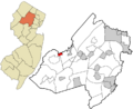
Location in Morris County and New Jersey
-
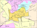
Census Bureau map of Netcong, New Jersey
See also
 In Spanish: Netcong para niños
