Jefferson Township, New Jersey facts for kids
Quick facts for kids
Jefferson Township, New Jersey
|
||
|---|---|---|
|
Township
|
||

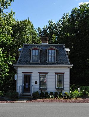
George Chamberlain House
|
||
|
||
| Country | ||
| State | ||
| County | ||
| Incorporated | February 11, 1804 | |
| Named for | Thomas Jefferson | |
| Government | ||
| • Type | Faulkner Act (mayor–council) | |
| • Body | Township Council | |
| Area | ||
| • Total | 42.77 sq mi (110.78 km2) | |
| • Land | 38.90 sq mi (100.75 km2) | |
| • Water | 3.88 sq mi (10.04 km2) 9.06% | |
| Area rank | 46th of 565 in state 3rd of 39 in county |
|
| Elevation | 1,142 ft (348 m) | |
| Population
(2020)
|
||
| • Total | 20,538 | |
| • Estimate
(2023)
|
20,534 | |
| • Rank | 134th of 565 in state 8th of 39 in county |
|
| • Density | 527.9/sq mi (203.8/km2) | |
| • Density rank | 441st of 565 in state 35th of 39 in county |
|
| Time zone | UTC−05:00 (Eastern (EST)) | |
| • Summer (DST) | UTC−04:00 (Eastern (EDT)) | |
| ZIP Code | ||
| Area code(s) | 973 | |
| FIPS code | 3402734980 | |
| GNIS feature ID | 0882210 | |
| Website | ||
Jefferson Township is a community located in Morris County, in the U.S. state of New Jersey. It is the northernmost township in the county. In 2020, the township had a population of 20,538 people.
Jefferson Township was officially formed on February 11, 1804. It was created from parts of Pequannock Township and Roxbury. The township was named after Thomas Jefferson, who was the President of the United States at that time.
Contents
Geography of Jefferson Township
Jefferson Township covers about 42.77 square miles (110.78 square kilometers). A small part of this area, about 3.88 square miles (10.04 square kilometers), is water.
Neighboring Towns
The township shares borders with several other towns. In Morris County, it borders Mount Arlington, Rockaway Township, Roxbury, and Wharton. It also borders West Milford in Passaic County. In Sussex County, it borders Hardyston Township, Hopatcong, and Sparta.
Main Divisions and Communities
Jefferson Township has two main parts: Milton and Lake Hopatcong. Each part has its own emergency services like a first-aid squad and fire department. They also have separate elementary schools.
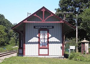
Many smaller communities and places are located within the township. These include Cozy Lake, Lake Shawnee, Newfoundland, and Oak Ridge. The main township buildings, middle school, and high school are located between these two main divisions.
Some parts of the township are owned by the City of Newark. This land is part of the Pequannock River Watershed, which supplies water to Newark.
Population and People
| Historical population | |||
|---|---|---|---|
| Census | Pop. | %± | |
| 1810 | 1,281 | — | |
| 1820 | 1,231 | −3.9% | |
| 1830 | 1,551 | 26.0% | |
| 1840 | 1,412 | −9.0% | |
| 1850 | 1,358 | −3.8% | |
| 1860 | 1,471 | 8.3% | |
| 1870 | 1,430 | −2.8% | |
| 1880 | 1,792 | 25.3% | |
| 1890 | 1,611 | −10.1% | |
| 1900 | 1,341 | −16.8% | |
| 1910 | 1,303 | −2.8% | |
| 1920 | 1,226 | −5.9% | |
| 1930 | 1,254 | 2.3% | |
| 1940 | 1,548 | 23.4% | |
| 1950 | 2,744 | 77.3% | |
| 1960 | 6,884 | 150.9% | |
| 1970 | 14,122 | 105.1% | |
| 1980 | 16,413 | 16.2% | |
| 1990 | 17,825 | 8.6% | |
| 2000 | 19,717 | 10.6% | |
| 2010 | 21,314 | 8.1% | |
| 2020 | 20,538 | −3.6% | |
| 2023 (est.) | 20,534 | −3.7% | |
| Population sources: 1810–1920 1840 1850–1870 1850 1870 1880–1890 1890–1910 1910–1930 1900–1990 2000 2010 2020 |
|||
Population Changes Over Time
The population of Jefferson Township has changed a lot over the years. In 1810, there were 1,281 people. By 1950, it had grown to 2,744. The population grew much faster in the second half of the 20th century.
In 2010, the township had 21,314 residents. By 2020, the population slightly decreased to 20,538.
Who Lives Here?
According to the 2010 census, most residents (about 90.6%) were White. About 4.6% were Asian, and 1.6% were Black or African American. People of Hispanic or Latino background made up about 6.5% of the population.
About 24.6% of the population was under 18 years old. The average age in the township was about 40.9 years.
Arts and Culture
Jefferson Township Day
Every year, after Independence Day, Jefferson Township hosts a special event called "Jefferson Township Day." It's a day of fun and celebration held at the Jefferson Township High School.
There are many activities for everyone, including games for kids, food and craft vendors, and live performances. The Jefferson Township Community Band performs before a fireworks display at night. A song called "My Sweet Home Jefferson" is often sung at these celebrations.
Jefferson Township Museum
The George Chamberlain House is a historic building in the township. It was built as a wedding gift in the 1800s. For many years, it was rented out to different families.
In 1960, a group called "Friends of the Library" bought the house. They worked for 19 years to turn it into a library, which opened in 1979. It was named the Violet Riker Library. In 1982, the township took over the library and decided to turn it into a museum. After a lot of repair work, it became the Jefferson Township Museum.
Education
The Jefferson Township Public Schools serve students from pre-kindergarten all the way through twelfth grade. The school district has seven schools. In the 2018–19 school year, there were 2,926 students and 267.5 teachers. This means there was about one teacher for every 10 or 11 students.
The schools in the district are:
- Milton School (Pre-K–K)
- Ellen T. Briggs School (K–2)
- Cozy Lake School (1–2)
- Arthur T. Stanlick School (3–5)
- White Rock Elementary School (3–5)
- Jefferson Township Middle School (6–8)
- Jefferson Township High School (9–12)
Transportation
Roads and Highways
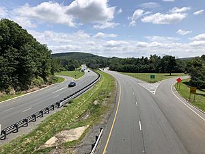
Jefferson Township has over 133 miles of roads. Most of these roads are maintained by the township itself. Some major roads pass through the area. These include Route 15 and Route 23. Interstate 80 also passes through a small part of the township.
Public Transportation
Lakeland Bus Lines provides bus service for people traveling between Newton and Midtown Manhattan in New York City. These buses use Interstate 80.
Notable People
Many interesting people have lived in or are connected to Jefferson Township:
- Derek Drymon (born 1968), a former creative director for SpongeBob SquarePants.
- Tim Jacobus (born 1959), an artist famous for illustrating many Goosebumps book covers.
- Mike Leach (born 1976), a former NFL player.
- Bob Malone (born 1965), a keyboardist, singer, and songwriter.
- Deonna Purrazzo (born 1994), a professional wrestler.
- Jerry Reese (born 1963), a former General Manager for the New York Giants football team.
- Jaren Sina (born 1994), a professional basketball player.
- Douglas Yeo (born 1955), a bass trombonist.
See also
 In Spanish: Municipio de Jefferson (Nueva Jersey) para niños
 | Toni Morrison |
 | Barack Obama |
 | Martin Luther King Jr. |
 | Ralph Bunche |


