Kerrtown, Pennsylvania facts for kids
Quick facts for kids
Kerrtown, Pennsylvania
|
|
|---|---|

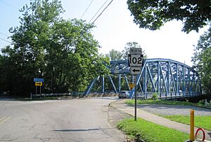
PA 102 at Mercer Street in Kerrtown
|
|
| Country | United States |
| State | Pennsylvania |
| County | Crawford |
| Township | Vernon |
| Area | |
| • Total | 0.85 sq mi (2.20 km2) |
| • Land | 0.85 sq mi (2.20 km2) |
| • Water | 0.00 sq mi (0.00 km2) |
| Elevation | 1,100 ft (300 m) |
| Population
(2020)
|
|
| • Total | 258 |
| • Density | 304.25/sq mi (117.49/km2) |
| Time zone | UTC-5 (Eastern (EST)) |
| • Summer (DST) | UTC-4 (EDT) |
| ZIP code |
16335
|
| FIPS code | 42-39504 |
| GNIS feature ID | 2633702 |
Kerrtown is a small community located in Vernon Township, within Crawford County, Pennsylvania, United States. It is known as a census-designated place, which means the government counts its population separately for statistics, even though it doesn't have its own local government like a city or town.
Kerrtown is situated where several important roads meet. These include U.S. Routes 6, 19, and 322, along with Pennsylvania Route 102. It lies just west of the city of Meadville.
Kerrtown's Population Over Time
The number of people living in Kerrtown changes over the years. This information is collected during a special count called the U.S. Decennial Census, which happens every ten years.
How Many People Live in Kerrtown?
- In 2010, the population of Kerrtown was 305 people.
- By 2020, the population was recorded as 258 people.
See also
 In Spanish: Kerrtown para niños
Black History Month on Kiddle
Famous African-American Activists:
 | William L. Dawson |
 | W. E. B. Du Bois |
 | Harry Belafonte |

All content from Kiddle encyclopedia articles (including the article images and facts) can be freely used under Attribution-ShareAlike license, unless stated otherwise. Cite this article:
Kerrtown, Pennsylvania Facts for Kids. Kiddle Encyclopedia.


